


Hurricane Ian expected to make landfall as a category 3 or 4 storm
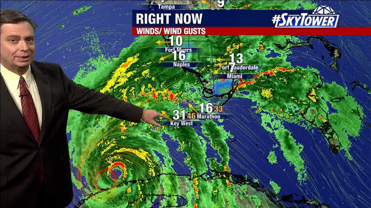
As of 11 p.m. Tuesday night, Hurricane Ian was 110 miles southwest of Naples. FOX 13 Chief Meteorologist Paul Dellegatto expects Ian to make landfall near the Cape Coral/ Fort Myers area as a category 3 or 4 hurricane. He says Ian will cause a storm surge. He also expects a lot of residents in Tampa and southward to lose power. Dellegatto says he wouldn?t be surprise if Tampa Bay had less water in it by Wednesday morning due to a northeast wind pushing the water offshore. He said we can expect winds of up to 100 miles per hour in southern Sarasota County and toward Fort Myers.
As of 11 p.m. Tuesday night, Hurricane Ian was 110 miles southwest of Naples. FOX 13 Chief Meteorologist Paul Dellegatto expects Ian to make landfall near the Cape Coral/ Fort Myers area as a category 3 or 4 hurricane. He says Ian will cause a storm surge. He also expects a lot of residents in Tampa and southward to lose power. Dellegatto says he wouldn?t be surprise if Tampa Bay had less water in it by Wednesday morning due to a northeast wind pushing the water offshore. He said we can expect winds of up to 100 miles per hour in southern Sarasota County and toward Fort Myers.

Hurricane Ian track forecast shifts south of Tampa Bay
Hurricane Ian's track has shifted south of the Tampa Bay area Tuesday evening, but the storm continue to strengthen as it moves toward Florida's Gulf Coast.?
Hurricane Ian's track has shifted south of the Tampa Bay area Tuesday evening, but the storm continue to strengthen as it moves toward Florida's Gulf Coast.?

Hurricane Ian set to make landfall along Florida Wednesday evening
Meteorologist Tyler Eliasen says Hurricane Ian, a Category 3 storm at 4:30 p.m. Tuesday, should make landfall along Florida's Gulf Coast sometime Wednesday evening. The storm will likely intensify before making landfall.
Meteorologist Tyler Eliasen says Hurricane Ian, a Category 3 storm at 4:30 p.m. Tuesday, should make landfall along Florida's Gulf Coast sometime Wednesday evening. The storm will likely intensify before making landfall.
Hurricane Ian latest forecast shows shift southeast of Tampa Bay
The latest models on Hurricane Ian show the storm shifting drastically southeast of Tampa Bay. Meteorologist Jim Weber says serious flooding is still likely up the west coast of Florida.
The latest models on Hurricane Ian show the storm shifting drastically southeast of Tampa Bay. Meteorologist Jim Weber says serious flooding is still likely up the west coast of Florida.

Hurricane Ian tropical forecast: September 27, 2022
The 8 a.m. track for Hurricane Ian on Sept. 27 shifted east but impacts remain the same for Tampa Bay, says FOX 13's meteorologist Dave Osterberg.
The 8 a.m. track for Hurricane Ian on Sept. 27 shifted east but impacts remain the same for Tampa Bay, says FOX 13's meteorologist Dave Osterberg.

How will Hurricane Ian impact Tampa Bay?
From Citrus County to Highlands County, FOX 13's meteorologist Dave Osterberg offers what can be expected for each county in the viewing area based on the current forecast track for Hurricane Ian, as of Tuesday, Sept. 27, 2022.
From Citrus County to Highlands County, FOX 13's meteorologist Dave Osterberg offers what can be expected for each county in the viewing area based on the current forecast track for Hurricane Ian, as of Tuesday, Sept. 27, 2022.

Hurricane Ian: Forecast, track for September 27, 2022
FOX 13's meteorologist Dave Osterberg offers the latest on Hurricane Ian's path, strengthening forecast and likely impacts for the Tampa Bay area.
FOX 13's meteorologist Dave Osterberg offers the latest on Hurricane Ian's path, strengthening forecast and likely impacts for the Tampa Bay area.

Hurricane Ian strengthens into category 2
Hurricane Ian is continuing to quickly intensify and has prompted hurricane and storm surge warnings for parts of the Tampa Bay area. As of the 5 p.m. advisory, the storm has strengthened into a category 2 hurricane with winds now up to 100 mph.?
Hurricane Ian is continuing to quickly intensify and has prompted hurricane and storm surge warnings for parts of the Tampa Bay area. As of the 5 p.m. advisory, the storm has strengthened into a category 2 hurricane with winds now up to 100 mph.?

Hurricane Ian forecast to bring major flooding to Florida
Meteorologist Jim Weber says Hurricane Ian will strengthen to a major hurricane as it moves slowly up the west coast of Florida, causing major flood hazards along the way.
Meteorologist Jim Weber says Hurricane Ian will strengthen to a major hurricane as it moves slowly up the west coast of Florida, causing major flood hazards along the way.

Hurricane Ian forms in Caribbean Sea
Meteorologist Dave Osterberg explains the possible impacts to the west coast of Florida based on the current path. Ian reached hurricane status Monday morning.
Meteorologist Dave Osterberg explains the possible impacts to the west coast of Florida based on the current path. Ian reached hurricane status Monday morning.

Hurricane Ian forms in Caribbean Sea
Meteorologist Dave Osterberg explains the possible impacts to the west coast of Florida based on the current path. Ian reached hurricane status Monday morning.
Meteorologist Dave Osterberg explains the possible impacts to the west coast of Florida based on the current path. Ian reached hurricane status Monday morning.

Latest FOX Weather model shows Ian making landfall near Tampa Bay
FOX 13 Chief Meteorologist Paul Dellegatto says the models are starting to come to agreement, with FOX Weather's model showing Tropical Storm Ian becoming a major hurricane before making landfall near Tampa Bay.
FOX 13 Chief Meteorologist Paul Dellegatto says the models are starting to come to agreement, with FOX Weather's model showing Tropical Storm Ian becoming a major hurricane before making landfall near Tampa Bay.

Tropical Storm Ian evening update: September 26, 2022
FOX13?s Chief Meteorologist Paul Dellegatto says it?s ?all signs go? when it comes to Tropical Storm Ian. He says the storm will enter a spot in the northwest Caribbean Sea Sunday night and Monday morning with very warm water and very light shear, which means there is nothing to stop Ian from rapidly intensifying. Dellegatto says the big questions are what position the storm will take and what structure it will have as it near the Florida coast late Wednesday night into Thursday morning. Dellegato says he will not be surprised if a Hurricane Watch is issued for a portion of Florida on Monday. The models show Tropical Storm Ian running parallel with the state, which is not good news for Florida because it increases the storm surge risk.
FOX13?s Chief Meteorologist Paul Dellegatto says it?s ?all signs go? when it comes to Tropical Storm Ian. He says the storm will enter a spot in the northwest Caribbean Sea Sunday night and Monday morning with very warm water and very light shear, which means there is nothing to stop Ian from rapidly intensifying. Dellegatto says the big questions are what position the storm will take and what structure it will have as it near the Florida coast late Wednesday night into Thursday morning. Dellegato says he will not be surprised if a Hurricane Watch is issued for a portion of Florida on Monday. The models show Tropical Storm Ian running parallel with the state, which is not good news for Florida because it increases the storm surge risk.

Tropical Storm Ian update: September 25, 2022
Fox 13 Meteorologist Tony Sadiku is watching Tropical Storm Ian closely. As of Sunday morning, Tropical Storm Ian had top winds of 50 miles per hour and was moving west-northwest at 12 miles per hour. Ian is expected to intensify rapidly and Sadiku says it could become a category 1 hurricane by late Sunday night or early Monday morning. According to Sadiku, the entire west coast of Florida is fair game for a hurricane landfall next week. He advises residents to get prepared now, so those plans can be implemented when there is a better idea of where the storm will hit.
Fox 13 Meteorologist Tony Sadiku is watching Tropical Storm Ian closely. As of Sunday morning, Tropical Storm Ian had top winds of 50 miles per hour and was moving west-northwest at 12 miles per hour. Ian is expected to intensify rapidly and Sadiku says it could become a category 1 hurricane by late Sunday night or early Monday morning. According to Sadiku, the entire west coast of Florida is fair game for a hurricane landfall next week. He advises residents to get prepared now, so those plans can be implemented when there is a better idea of where the storm will hit.

Tropical Storm Ian still developing south of Cuba
Meteorologist Tony Sadiku shows how Ian continues to develop over the Caribbean as it battles wind shear, but Sunday will bring it north, likely developing into a hurricane by Monday.
Meteorologist Tony Sadiku shows how Ian continues to develop over the Caribbean as it battles wind shear, but Sunday will bring it north, likely developing into a hurricane by Monday.

Tropical Storm Ian shifts slightly west, with uncertain track
The 5 p.m. update from the National Hurricane Center Saturday showed Ian tracking west of the Tampa Bay area, but the storm was still too far away for predicting a path. NHC sails "uncertainty in the track forecast is higher than usual."
The 5 p.m. update from the National Hurricane Center Saturday showed Ian tracking west of the Tampa Bay area, but the storm was still too far away for predicting a path. NHC sails "uncertainty in the track forecast is higher than usual."

Tropical Storm Ian Update; September 24, 2022
All eyes are on Tropical Storm Ian that could impact the state of Florida next week. FOX 13 Meteorologist Tony Sadiku says Ian is battling a lot of wind shear and appears to be lopsided, which makes it tough to identify a center of circulation. However, Sadkiu says Ian is going to rapidly intensify as it passes just south of Jamaica and could become a hurricane by Sunday. Florida is within Tropical Storm Ian?s cone of uncertainty, and though it is too early to talk specifics, Sadiku says it is important to get prepared now.
All eyes are on Tropical Storm Ian that could impact the state of Florida next week. FOX 13 Meteorologist Tony Sadiku says Ian is battling a lot of wind shear and appears to be lopsided, which makes it tough to identify a center of circulation. However, Sadkiu says Ian is going to rapidly intensify as it passes just south of Jamaica and could become a hurricane by Sunday. Florida is within Tropical Storm Ian?s cone of uncertainty, and though it is too early to talk specifics, Sadiku says it is important to get prepared now.

Tropical Storm Ian expected to strengthen
Tropical Storm Ian has formed in the Central Caribbean Sea late Friday evening and is projected to continue strengthening. Florida remains in the cone of uncertainty as of the 11 p.m. advisory on the storm.?
Tropical Storm Ian has formed in the Central Caribbean Sea late Friday evening and is projected to continue strengthening. Florida remains in the cone of uncertainty as of the 11 p.m. advisory on the storm.?

Tropical Storm Ian forms
Tropical Storm Ian has formed in the Central Caribbean Sea late Friday evening and is projected to continue strengthening. Florida remains in the cone of uncertainty as of the 11 p.m. advisory on the storm.
Tropical Storm Ian has formed in the Central Caribbean Sea late Friday evening and is projected to continue strengthening. Florida remains in the cone of uncertainty as of the 11 p.m. advisory on the storm.

Tropical Depression 9 expected to strengthen
As of the 5 p.m. advisory, Tropical Depression 9 was located over 400 miles east southeast of Jamaica. The system is still battling a bit of northeasterly wind shear, but it'll be moving into an environment much more conducive for organization this weekend.
As of the 5 p.m. advisory, Tropical Depression 9 was located over 400 miles east southeast of Jamaica. The system is still battling a bit of northeasterly wind shear, but it'll be moving into an environment much more conducive for organization this weekend.