


Thursday morning forecast
Meteorologist Dave Osterberg
Meteorologist Dave Osterberg

Wednesday evening forecast
Chief Meteorologist Paul Dellegatto
Chief Meteorologist Paul Dellegatto

Wednesday afternoon forecast
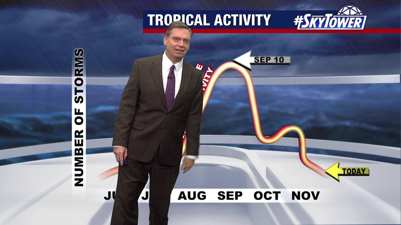
Meteorologist Jim Weber
Meteorologist Jim Weber

All quiet with 2 days left in hurricane season
All is quiet in the tropics with two days left in the hurricane season.
All is quiet in the tropics with two days left in the hurricane season.

Wednesday morning forecast
Meteorologist Dave Osterberg
Meteorologist Dave Osterberg

Tuesday evening forecast
Chief Meteorologist Paul Dellegatto
Chief Meteorologist Paul Dellegatto

No development expected as hurricane season closes
Meteorologist Jim Weber expects no tropical development as the hurricane season draws to a close and looks back on what was a busy hurricane season.
Meteorologist Jim Weber expects no tropical development as the hurricane season draws to a close and looks back on what was a busy hurricane season.

Tuesday afternoon forecast
Meteorologist Jim Weber
Meteorologist Jim Weber

Tuesday morning forecast
Meteorologist Dave Osterberg
Meteorologist Dave Osterberg

Monday evening forecast
Chief Meteorologist Paul Dellegatto
Chief Meteorologist Paul Dellegatto

Monday afternoon forecast
Meteorologist Jim Weber
Meteorologist Jim Weber
Tropics to remain quiet as season winds down
FOX 13 Meteorologist Jim Weber is keeping an eye on the tropics as the final week of the 2023 hurricane season gets underway. He says nothing is expected to develop over the next week, which takes us past the end of hurricane season.
FOX 13 Meteorologist Jim Weber is keeping an eye on the tropics as the final week of the 2023 hurricane season gets underway. He says nothing is expected to develop over the next week, which takes us past the end of hurricane season.

Monday morning forecast
Meteorologist Dave Osterberg
Meteorologist Dave Osterberg

Sunday evening forecast
Meteorologist Valerie Mills
Meteorologist Valerie Mills

Atlantic basin quiet as tropics shut down
According to FOX 13 News Meteorologist Valerie Mills, the little wave that was being watched in the far open waters has been downgraded. Mills say there's no chance of development as it moves into the northeast, into colder ocean waters.
According to FOX 13 News Meteorologist Valerie Mills, the little wave that was being watched in the far open waters has been downgraded. Mills say there's no chance of development as it moves into the northeast, into colder ocean waters.

Sunday morning forecast
Meteorologist Valerie Mills
Meteorologist Valerie Mills

Saturday evening forecast
Meteorologist Jim Weber
Meteorologist Jim Weber

Wave in Atlantic has chance of gaining strength
According to FOX 13 Meteorologist Valerie Mills, the wave that has a chance of gaining tropical characteristics will stay in open waters. Mills says it only has a short window to develop.
According to FOX 13 Meteorologist Valerie Mills, the wave that has a chance of gaining tropical characteristics will stay in open waters. Mills says it only has a short window to develop.

Saturday morning forecast
Meteorologist Valerie Mills
Meteorologist Valerie Mills

Short window for area of low pressure to develop
FOX 13 Meteorologist Valerie Mills says there's a 30% chance for an area of low pressure to gain some subtropical or tropical characteristics. According to Mills, once the area moves to cooler waters, potential for development will quickly die.
FOX 13 Meteorologist Valerie Mills says there's a 30% chance for an area of low pressure to gain some subtropical or tropical characteristics. According to Mills, once the area moves to cooler waters, potential for development will quickly die.