

Tampa Bay History Center's new exhibit reveals Florida's untold Revolutionary-era history
History of Loyalists in Florida
Florida has long had a reputation for independence. But during the American Revolution, the land that is part of the modern-day Tampa Bay area was not fighting for freedom from Britain. FOX 13's Matthew McClellan reports.
TAMPA, Fla. - Florida has long had a reputation for independence. But during the American Revolution, the land that is part of the modern-day Tampa Bay area was not fighting for freedom from Britain.
It was part of British East Florida, a colony loyal to King George III.
That overlooked chapter of history is at the center of "Mapping the 14th Colony," a new exhibit at the Tampa Bay History Center that runs July 3 through Oct. 11, 2026. Through British maps, charts and Revolutionary-era records, the exhibit shows how Florida’s path through the Revolution looked very different from the story told in the original 13 colonies.
Florida Revolutionary-era history
Timeline:
While the original 13 colonies rebelled, British Florida stayed loyal to the Crown.

Spain ceded Florida to Britain in 1763, after the Seven Years’ War. Britain then divided the territory into two colonies: East Florida and West Florida. In Revolutionary-era shorthand, they are sometimes described as the 14th and 15th colonies, though they were not part of the rebelling 13.
"Florida was actually two separate colonies, 14 and 15, if you want to call them that," Rodney Kite-Powell, director of the Touchton Map Library at the Tampa Bay History Center, said. "Unlike Canada, which is still its own country, we became part of the U.S. It just took us a much longer route than the other 13 colonies to the north."
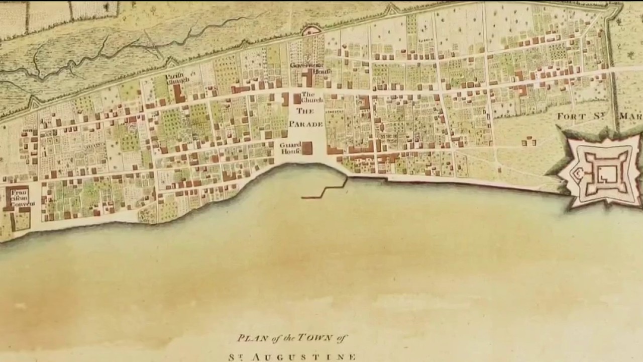
Instead of joining George Washington’s fight, East Florida became a refuge for Loyalists. St. Augustine, the fortified capital of East Florida, drew refugees from Georgia and the Carolinas.
The anti-rebel sentiment was not subtle.
When news of the Declaration of Independence reached St. Augustine on Aug. 11, 1776, John Hancock and Samuel Adams were burned in effigy.
"When the Declaration of Independence was announced in St. Augustine, some of the signers were actually burned in effigy," Kite-Powell said. "We were a loyal stronghold."
Mapping Bay Area for the Crown
Dig deeper:
After Britain acquired Florida, British surveyors began charting the Gulf Coast to make unfamiliar waters safer for ships, settlement, trade and defense.
Those maps later took on military importance as Spain entered the war and attacked British West Florida.
The British Admiralty assigned surveyors, including George Gauld, to chart Gulf waters from New Orleans to the west coast of modern Florida. Bernard Romans, a surveyor working in British service, is credited with early maps of Pensacola Harbor, Tampa Bay and Mobile Bay.
As British surveyors mapped the region, they also Anglicized local place names. Some of those names remain part of the Bay Area’s geography.
Egmont Key was named for John Perceval, the second Earl of Egmont. Hillsborough Bay and the Hillsborough River were named for Wills Hill, the Earl of Hillsborough, who served as Britain’s colonial secretary.
"So many of the places that we think of today or that we know of today actually got their names during this time," Kite-Powell said.
Mapping Florida was difficult and often dangerous.
The region’s swamps, rivers, islands and coastlines were hard to distinguish, leading some early cartographers to draw southern Florida as a chain of large islands.
Surveyors also faced severe weather, rough waters and wildlife. Wooden ships could be damaged or sunk in sudden squalls. Those who made it ashore faced an unfamiliar frontier.
"There’s bears and panthers that also make things a little more dangerous," Kite-Powell said. "So, it was not the safest job to have."
The exhibit’s design leans into the surprise of Florida’s Loyalist history.
Museum leaders' perspective
What they're saying:
Teresa Silva, the Tampa Bay History Center’s creative director, incorporated the 18th-century British Union flag into the exhibit’s logo to give visitors an immediate visual cue that Florida’s Revolutionary story does not follow the standard 13-colonies narrative.

"I think it will be definitely a talking point," Silva said. "That’s part of my job, is to give them that a-ha moment or something that will trigger, ‘Wow, wait.’"
For the museum, the exhibit is meant to add Florida context to the nation’s 250th birthday.
"As we celebrate America 250, this exhibit really does highlight Florida’s place in that timeframe and helps us to have context to what was happening in Tampa and West Central Florida during the revolution," Billy Somerville, senior director of marketing and communications for the Tampa Bay History Center, said.
Exhibit information
What: "Mapping the 14th Colony"
Where: Touchton Map Library at the Tampa Bay History Center
When: July 3 through Oct. 11, 2026
Bonus: Some map facsimiles are available in the museum store.
The Source: The records, charts, and materials anchoring this story belong to the permanent collection of the Touchton Map Library at the Tampa Bay History Center. Roughly 95% of the History Center's cartographic collection has been digitized for public access. Information for this story was also gathered from interviews with Tampa Bay History Center employees, including the senior director of marketing and communications and the director of the Touchton Map Library.