


Hurricane Tammy continues to weaken
FOX 13 Meteorologist Dave Osterberg is keeping his eye on the tropics as the weekend comes to a close. Dave is watching Hurricane Tammy, which is affecting the Leeward Islands. The storm is expected to stay in open waters as it moves northwest and morphs into a tropical storm next week.
FOX 13 Meteorologist Dave Osterberg is keeping his eye on the tropics as the weekend comes to a close. Dave is watching Hurricane Tammy, which is affecting the Leeward Islands. The storm is expected to stay in open waters as it moves northwest and morphs into a tropical storm next week.

Hurricane Tammy impacting the Caribbean
Fox 13 Meteorologist Valerie Mills is keeping her eyes on the tropics to start the weekend. Mills is watching Hurricane Tammy, which is currently hitting the Caribbean. The storm is expected to bring a lot of rain and wind to the region on Saturday and Sunday. At the end of the weekend, the storm is expected to move into open waters as it loses strength..
Fox 13 Meteorologist Valerie Mills is keeping her eyes on the tropics to start the weekend. Mills is watching Hurricane Tammy, which is currently hitting the Caribbean. The storm is expected to bring a lot of rain and wind to the region on Saturday and Sunday. At the end of the weekend, the storm is expected to move into open waters as it loses strength..

Hurricane Tammy forms in Atlantic
FOX 13 Meteorologist Valerie Mills is keeping an eye on Hurricane Tammy, which formed early Friday morning. Advisories and warnings are in effect for the northern Leeward Islands. As of Friday afternoon, Hurricane Tammy had sustained winds of 75 miles an hour. Mills says Hurricane Tammy will take a sharp northern turn after skirting the Leeward Islands and head out to sea.
FOX 13 Meteorologist Valerie Mills is keeping an eye on Hurricane Tammy, which formed early Friday morning. Advisories and warnings are in effect for the northern Leeward Islands. As of Friday afternoon, Hurricane Tammy had sustained winds of 75 miles an hour. Mills says Hurricane Tammy will take a sharp northern turn after skirting the Leeward Islands and head out to sea.

Tropical Storm Tammy forms in Atlantic
FOX 13 Meteorologist Jim Weber is keeping an eye on Tropical Storm Tammy, which is getting more organized. Weber says Tropical Storm Tammy has winds of 60 miles an hour and is moving west-northwest at 15 miles an hour. According to Weber, the storm will brush the islands and then strengthen into a Category 1 hurricane as it works its way north over open waters.
FOX 13 Meteorologist Jim Weber is keeping an eye on Tropical Storm Tammy, which is getting more organized. Weber says Tropical Storm Tammy has winds of 60 miles an hour and is moving west-northwest at 15 miles an hour. According to Weber, the storm will brush the islands and then strengthen into a Category 1 hurricane as it works its way north over open waters.

Strengthening storm system to impact islands in Atlantic
FOX 13 Meteorologist Jim Weber continues to watch Invest 94, which has an 80 percent chance of development over the next week. He says it is a broad area of low pressure, but all signs show it will likely become the next tropical depression and may strengthen into Tropical Storm Tammy. Weber says it will strengthen but may weaken as it approaches the islands near Puerto Rico. Then it will likely move north.
FOX 13 Meteorologist Jim Weber continues to watch Invest 94, which has an 80 percent chance of development over the next week. He says it is a broad area of low pressure, but all signs show it will likely become the next tropical depression and may strengthen into Tropical Storm Tammy. Weber says it will strengthen but may weaken as it approaches the islands near Puerto Rico. Then it will likely move north.

Atlantic system to strengthen
FOX 13 Meteorologist Jim Weber is monitoring Invest 94 as it swirls in the Atlantic. He says it has an 80 percent chance of developing over the next week. While it is not a well-formed system at this point, Weber says it looks like it will strengthen, but it is unclear how strong it will get and how long it will last as models show it weakening shortly after it develops. The next name on the list is Tammy.
FOX 13 Meteorologist Jim Weber is monitoring Invest 94 as it swirls in the Atlantic. He says it has an 80 percent chance of developing over the next week. While it is not a well-formed system at this point, Weber says it looks like it will strengthen, but it is unclear how strong it will get and how long it will last as models show it weakening shortly after it develops. The next name on the list is Tammy.

Tropical Storm Tammy could form this week
FOX 13 Meteorologist Jim Weber is keeping an eye on the tropics, which remain active ad we head into mid-October. He says Invest 94, which is off the coast of Africa, may become Tropical Storm Tammy later this week. Weber says it appears to be moving west and then will likely make a turn to the north, but it is too soon to tell where exactly it is headed and how much it will strengthen.
FOX 13 Meteorologist Jim Weber is keeping an eye on the tropics, which remain active ad we head into mid-October. He says Invest 94, which is off the coast of Africa, may become Tropical Storm Tammy later this week. Weber says it appears to be moving west and then will likely make a turn to the north, but it is too soon to tell where exactly it is headed and how much it will strengthen.

Tropical Storm Sean continues to lose strength
FOX 13 Meteorologist Jim Weber is keeping his eye on the tropics as the second weekend of October ends. Jim is watching Tropical Storm Sean, which he says should end by Monday. He is also watching Invest 94L, which is currently disorganized but showing signs of organizing. Invest 94L is expected to move west over the next few days.
FOX 13 Meteorologist Jim Weber is keeping his eye on the tropics as the second weekend of October ends. Jim is watching Tropical Storm Sean, which he says should end by Monday. He is also watching Invest 94L, which is currently disorganized but showing signs of organizing. Invest 94L is expected to move west over the next few days.

Tropic Storm Sean hanging on by a thread
FOX 13 Meteorologist Tony Sadiku is keeping his eyes on the tropics in the second week of October. Tony is watching Tropical Storm Sean, which he says is hanging on by a thread. He is also watching a cluster of storms in the Atlantic that has a 70 percent chance of developing in the next two days.
FOX 13 Meteorologist Tony Sadiku is keeping his eyes on the tropics in the second week of October. Tony is watching Tropical Storm Sean, which he says is hanging on by a thread. He is also watching a cluster of storms in the Atlantic that has a 70 percent chance of developing in the next two days.

Tropical Storm Sean to weaken
FOX 13 Meteorologist Valeria Mills is still watching Tropical Storm Sean as it continues to swirl in the Atlantic. She is also keeping an eye on Invest 94L, which is off the coast of Africa that has a 70 percent chance of developing over the next week. She expects Sean to drop down to a tropical depression by the end of the weekend. Mills added that Invest 94L may become the next named storm. It is does earn a name it will be called Tammy.
FOX 13 Meteorologist Valeria Mills is still watching Tropical Storm Sean as it continues to swirl in the Atlantic. She is also keeping an eye on Invest 94L, which is off the coast of Africa that has a 70 percent chance of developing over the next week. She expects Sean to drop down to a tropical depression by the end of the weekend. Mills added that Invest 94L may become the next named storm. It is does earn a name it will be called Tammy.

Tropical Storm Sean continues to swirl in Atlantic
FOX 13 Meteorologist Valerie Mills is keeping an eye on some area of interest in the tropics, including Tropical Storm Sean. She says the storm was downgraded to a depression before regaining tropical storm status on Thursday. Another tropical wave, Invest 94L, which is behind Sean, has been given a 30 percent chance of development over the next week. Mills says both systems are out in the open Atlantic and are expected to stay out to sea.
FOX 13 Meteorologist Valerie Mills is keeping an eye on some area of interest in the tropics, including Tropical Storm Sean. She says the storm was downgraded to a depression before regaining tropical storm status on Thursday. Another tropical wave, Invest 94L, which is behind Sean, has been given a 30 percent chance of development over the next week. Mills says both systems are out in the open Atlantic and are expected to stay out to sea.

Tropical Storm Sean forms in Atlantic
FOX 13 Meteorologist Jim Weber is watching Tropical Storm Sean and Invest 94 as the tropics remain active this October. He says Tropical Storm Sean should stay over open waters and eventually dissipate. Behind Tropical Storm Sean is Invest 94, which is moving off the coast of Africa. However, Weber doesn?t expect it to strengthen any time soon.
FOX 13 Meteorologist Jim Weber is watching Tropical Storm Sean and Invest 94 as the tropics remain active this October. He says Tropical Storm Sean should stay over open waters and eventually dissipate. Behind Tropical Storm Sean is Invest 94, which is moving off the coast of Africa. However, Weber doesn?t expect it to strengthen any time soon.

Gulf system to bring rain to Florida
FOX 13 Meteorologist Jim Weber is keeping an eye on Invest 92 and a system in the Gulf of Mexico called Invest 93. He says Invest 93 has a small chance of developing, but it will move north and then trek east toward Florida, brining rain to the Sunshine State over the next several days. Weber says Invest 92 will likely become our next tropical depression or even tropical storm. However, he says it should remain over open waters. The next name on the list is Sean.
FOX 13 Meteorologist Jim Weber is keeping an eye on Invest 92 and a system in the Gulf of Mexico called Invest 93. He says Invest 93 has a small chance of developing, but it will move north and then trek east toward Florida, brining rain to the Sunshine State over the next several days. Weber says Invest 92 will likely become our next tropical depression or even tropical storm. However, he says it should remain over open waters. The next name on the list is Sean.

Gulf system unlikely to become tropical
FOX 13 Meteorologist Jim Weber is watching two area in the tropics. The first is an area of low pressure in the western Gulf of Mexico that will work its way north and get picked up by a subtropical jet stream. Weber says conditions are not conducive to see much development though. According to Weber it will be a large area of non-tropical weather that slides across the northern Gulf Coast in the middle of the week. Weber is also watching an area off the coast of Africa that has an 80- percent chance of developing over the next week, but he expects it to stay out over open waters.
FOX 13 Meteorologist Jim Weber is watching two area in the tropics. The first is an area of low pressure in the western Gulf of Mexico that will work its way north and get picked up by a subtropical jet stream. Weber says conditions are not conducive to see much development though. According to Weber it will be a large area of non-tropical weather that slides across the northern Gulf Coast in the middle of the week. Weber is also watching an area off the coast of Africa that has an 80- percent chance of developing over the next week, but he expects it to stay out over open waters.

Tropics quiet entering second week of october
Fox 13 Meteorologist Tony Sadiku is keeping his eyes on one area of tropical activity in the Atlantic. The tropical wave is being called Invest 92. Tony says Invest 92 has a 30 percent chance of developing over the next two days and an 80 percent chance over the next seven days. The wave is expected to move northwest and not affect land.
Fox 13 Meteorologist Tony Sadiku is keeping his eyes on one area of tropical activity in the Atlantic. The tropical wave is being called Invest 92. Tony says Invest 92 has a 30 percent chance of developing over the next two days and an 80 percent chance over the next seven days. The wave is expected to move northwest and not affect land.

Tropical wave forms off the coast of Africa
FOX 13 Meteorologist Tony Sadiku is keeping his eye on the tropics to start October. Tony is watching a tropical wave that has formed off the coast of Africa. The wave has a 20 percent chance of developing over the next two days and a 70 percent chance over the next seven days. While the storm isn't expected to have a major impact, Tony says we are not out of the woods yet, as hurricane season lasts until the end of November.
FOX 13 Meteorologist Tony Sadiku is keeping his eye on the tropics to start October. Tony is watching a tropical wave that has formed off the coast of Africa. The wave has a 20 percent chance of developing over the next two days and a 70 percent chance over the next seven days. While the storm isn't expected to have a major impact, Tony says we are not out of the woods yet, as hurricane season lasts until the end of November.

Philippe becomes post-tropical system
FOX 13 Meteorologist Jim Weber is watching the tropics, which remain fairly active. He says Tropical Storm Philippe has lost its tropical characteristics and is now a post-tropical storm. Weber says Philippe is headed to the Northeast United States and will bring heavy rain and winds to New England this weekend. Weber is also watching a tropical wave working its way off the coast of Africa that has a 50 percent chance of developing over the next week.
FOX 13 Meteorologist Jim Weber is watching the tropics, which remain fairly active. He says Tropical Storm Philippe has lost its tropical characteristics and is now a post-tropical storm. Weber says Philippe is headed to the Northeast United States and will bring heavy rain and winds to New England this weekend. Weber is also watching a tropical wave working its way off the coast of Africa that has a 50 percent chance of developing over the next week.
Tropical Storm Philippe strengthens
FOX 13 Meteorologist Jim Weber is still keeping an eye on Tropical Storm Philippe, which is gaining intensity despite strong wind shear. Weber says Philippe will pass to the west of Bermuda and work its way north toward New England. Philippe is expected to lose its tropical characteristics before landfall. However, the storm will still bring rain and winds to the northeast United States.
FOX 13 Meteorologist Jim Weber is still keeping an eye on Tropical Storm Philippe, which is gaining intensity despite strong wind shear. Weber says Philippe will pass to the west of Bermuda and work its way north toward New England. Philippe is expected to lose its tropical characteristics before landfall. However, the storm will still bring rain and winds to the northeast United States.
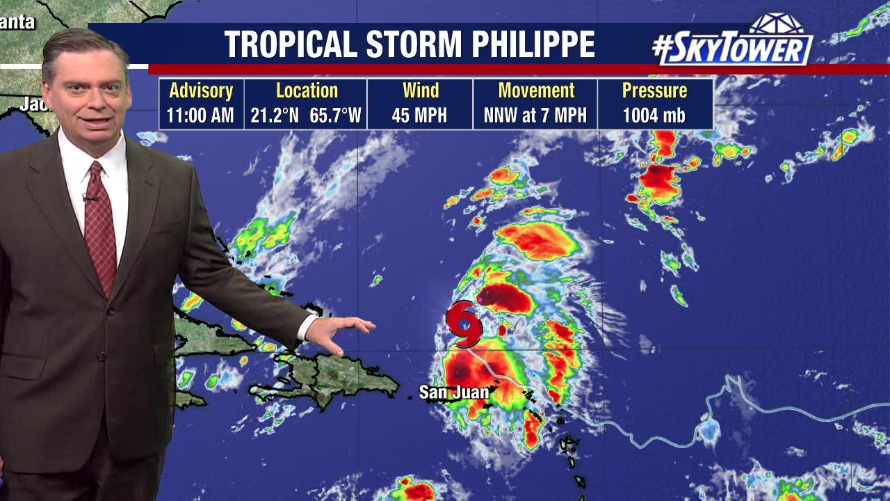
Tropical Storm Philippe sets sights on New England
FOX 13 Meteorologist Jim Weber is still watching Tropical Storm Philippe, which is still holding its own. Weber says the storm has a ragged appearance due to wind shear. He says Philippe has made a turn to the north and will continue heading north-northwest. According to Weber, Philippe will attach to a cold front and lose some of its tropical characteristics. However, it should bring heavy rain to the New England area as we head into the weekend.
FOX 13 Meteorologist Jim Weber is still watching Tropical Storm Philippe, which is still holding its own. Weber says the storm has a ragged appearance due to wind shear. He says Philippe has made a turn to the north and will continue heading north-northwest. According to Weber, Philippe will attach to a cold front and lose some of its tropical characteristics. However, it should bring heavy rain to the New England area as we head into the weekend.

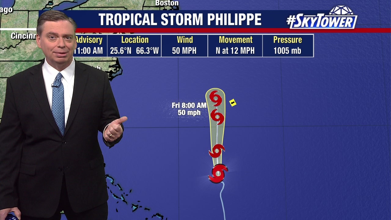
Tropical Storm Philippe churns in Atlantic
FOX 13 Meteorologist Jim Weber is watching Tropical Storm Philippe, which he now says will not likely strengthen into a hurricane by the end of the week. He said after a brief landfall yesterday, it is working its way back over open water where conditions aren?t conducive to becoming a hurricane, but it is still holding its own. He says the storm will move northward though where exactly it is heading is unclear. Weber says it may eventually impact land areas near Canada.
FOX 13 Meteorologist Jim Weber is watching Tropical Storm Philippe, which he now says will not likely strengthen into a hurricane by the end of the week. He said after a brief landfall yesterday, it is working its way back over open water where conditions aren?t conducive to becoming a hurricane, but it is still holding its own. He says the storm will move northward though where exactly it is heading is unclear. Weber says it may eventually impact land areas near Canada.