


Gulf system to enhance rain across Florida
FOX 13 Meteorologist Jim Weber is keeping an eye on the tropics, which remain active as we head into the tail end of September. He is watching a disorganized system that is moving away from Florida, but it will enhance showers and storms across Florida. Weber says Tropical Storm Philippe, which formed over the weekend, is expected to weaken as it encounters wind shear, staying over open waters. He is also watching Invest 91L, which he says will likely become the next tropical depression or tropical storm.
FOX 13 Meteorologist Jim Weber is keeping an eye on the tropics, which remain active as we head into the tail end of September. He is watching a disorganized system that is moving away from Florida, but it will enhance showers and storms across Florida. Weber says Tropical Storm Philippe, which formed over the weekend, is expected to weaken as it encounters wind shear, staying over open waters. He is also watching Invest 91L, which he says will likely become the next tropical depression or tropical storm.

Tropical Storm Philippe forms in the Atlantic
FOX 13 Meteorologist Tony Sadiku is keeping his eye on the tropics as September begins to wind down. A new Tropical Storm, Philippe, has formed in the Atlantic and currently has 45 miles per hour winds. Tony says the storm is moving west and is expected to stay out to see. The storm is expected to pass east of Bermuda and not reach Hurricane strength.
FOX 13 Meteorologist Tony Sadiku is keeping his eye on the tropics as September begins to wind down. A new Tropical Storm, Philippe, has formed in the Atlantic and currently has 45 miles per hour winds. Tony says the storm is moving west and is expected to stay out to see. The storm is expected to pass east of Bermuda and not reach Hurricane strength.

Invest 90L forms in the Atlantic
Fox 13 Meteorologist Tony Sadiku is keeping his eye on the tropics to start the weekend. Tony is watching Tropical Storm Ophelia, which made landfall in North Carolina on Saturday morning. As the storm moves north, it is expected to bring powerful winds and heavy rain. Tony is also watching a tropical disturbance called Invest 90L, which is expected to become a tropical storm within the next two days. The storm is projected to stay out at sea.
Fox 13 Meteorologist Tony Sadiku is keeping his eye on the tropics to start the weekend. Tony is watching Tropical Storm Ophelia, which made landfall in North Carolina on Saturday morning. As the storm moves north, it is expected to bring powerful winds and heavy rain. Tony is also watching a tropical disturbance called Invest 90L, which is expected to become a tropical storm within the next two days. The storm is projected to stay out at sea.

Tropical Storm Ophelia may form in Atlantic
FOX 13 Meteorologist Dave Osterberg says Potential Tropical Cyclone 16 will likely become Tropical Storm Ophelia. He says the system will slow down as it moves toward the Carolinas and begin transitioning into a tropical storm. According to Osterberg, the storm will bring rains and wind gusts of 50 miles an hour to the Carolinas. He is also keeping an eye on a system off the coast of Africa that he expects to eventually take a turn to the north and stay over open waters.
FOX 13 Meteorologist Dave Osterberg says Potential Tropical Cyclone 16 will likely become Tropical Storm Ophelia. He says the system will slow down as it moves toward the Carolinas and begin transitioning into a tropical storm. According to Osterberg, the storm will bring rains and wind gusts of 50 miles an hour to the Carolinas. He is also keeping an eye on a system off the coast of Africa that he expects to eventually take a turn to the north and stay over open waters.

Potential Tropical Cyclone 16 takes aim at Carolinas
FOX 13 Meteorologist Jim Weber is keeping an eye on Potential Tropical Cyclone 16, which formed off the Southeastern United States Thursday morning. While Weber says it is not a tropical system yet, models show it acquiring tropical characteristic within the next day or two as it works it way north. He says it may even strengthen into Tropical Storm Ophelia before making landfall in the Carolinas. Weber is also watching Hurricane Nigel, which will weaken and eventually dissipate over open waters. He also has his eye on a system off the coast of Africa that is expected to take time to develop, but may become Philippe.
FOX 13 Meteorologist Jim Weber is keeping an eye on Potential Tropical Cyclone 16, which formed off the Southeastern United States Thursday morning. While Weber says it is not a tropical system yet, models show it acquiring tropical characteristic within the next day or two as it works it way north. He says it may even strengthen into Tropical Storm Ophelia before making landfall in the Carolinas. Weber is also watching Hurricane Nigel, which will weaken and eventually dissipate over open waters. He also has his eye on a system off the coast of Africa that is expected to take time to develop, but may become Philippe.

Potential subtropical system to bring lower humidity to Florida
FOX 13 Meteorologist Jim Weber is watching an area of low pressure off Florida?s east coast that may develop subtropical characteristics. However, it will not bring rain and winds to Florida because it will move to the north and the northwest. It is expected to lower our humidity though as we head into the weekend. He is also keeping an eye on Hurricane Nigel as it swirls over open waters. A third area he is watching is a wave off the coast of Africa that will be slow moving and won?t show signs of development until next week.
FOX 13 Meteorologist Jim Weber is watching an area of low pressure off Florida?s east coast that may develop subtropical characteristics. However, it will not bring rain and winds to Florida because it will move to the north and the northwest. It is expected to lower our humidity though as we head into the weekend. He is also keeping an eye on Hurricane Nigel as it swirls over open waters. A third area he is watching is a wave off the coast of Africa that will be slow moving and won?t show signs of development until next week.

Subtropical system may develop off Florida
FOX 13 Meteorologist Jim Weber is keeping an eye on three things in the tropics including Hurricane Nigel, an area off the Southeastern U.S. that may develop and a wave that is working its way off the coast of Africa. He says a system could develop subtropical characteristics off the coast of Florida, but Weber says it will not impact the Sunshine State because it is headed north. Hurricane Nigel is a Category 1 storm that will likely strengthen, but it is expected to stay over open waters.
FOX 13 Meteorologist Jim Weber is keeping an eye on three things in the tropics including Hurricane Nigel, an area off the Southeastern U.S. that may develop and a wave that is working its way off the coast of Africa. He says a system could develop subtropical characteristics off the coast of Florida, but Weber says it will not impact the Sunshine State because it is headed north. Hurricane Nigel is a Category 1 storm that will likely strengthen, but it is expected to stay over open waters.

Hurricane Nigel forms in Atlantic
FOX 13 Meteorologist Jim Weber is watching Hurricane Nigel, which formed early Monday morning as we cross over the heart of hurricane season. Weber says that while Nigel is expected to strengthen, it will stay over open waters. Weber is also keeping an eye on an area off the southeast coast that could acquire some tropical characteristics over the next few days. He says another wave is also working its way off the coast of Africa and could develop as well.
FOX 13 Meteorologist Jim Weber is watching Hurricane Nigel, which formed early Monday morning as we cross over the heart of hurricane season. Weber says that while Nigel is expected to strengthen, it will stay over open waters. Weber is also keeping an eye on an area off the southeast coast that could acquire some tropical characteristics over the next few days. He says another wave is also working its way off the coast of Africa and could develop as well.

Tropical Storm Nigel forms, expected to become hurricane soon
FOX 13 Meteorologist Tony Sadiku is tracking Tropical Storm Nigel as it forms in the open Atlantic with the potential to shortly become a hurricane. He does not believe it will pose a threat to anyone on land, however. Lee and Margot continue to fizzle out, and a tropical wave moving off the coast of Africa now has a medium chance of development.
FOX 13 Meteorologist Tony Sadiku is tracking Tropical Storm Nigel as it forms in the open Atlantic with the potential to shortly become a hurricane. He does not believe it will pose a threat to anyone on land, however. Lee and Margot continue to fizzle out, and a tropical wave moving off the coast of Africa now has a medium chance of development.

New tropical disturbance brewing in Atlantic
FOX 13 Meteorologist Dave Osterberg gives the latest on Post-Tropical Lee as it fizzles out near Canada. He's also eyeing Tropical Depression Fifteen, which he expects to become the next named storm and eventually a hurricane. Meanwhile, Margot shouldn't become an imminent threat as it spins around in the Atlantic.
FOX 13 Meteorologist Dave Osterberg gives the latest on Post-Tropical Lee as it fizzles out near Canada. He's also eyeing Tropical Depression Fifteen, which he expects to become the next named storm and eventually a hurricane. Meanwhile, Margot shouldn't become an imminent threat as it spins around in the Atlantic.

Tropical Depression 15 forms as Hurricane Lee prepares for landfall
FOX 13 Meteorologist Jim Weber is watching the newly formed Tropical Depression 15 as Hurricane Lee makes its way toward New England. He expects Lee to make landfall on Saturday as an extratropical storm. Weber also has his eye on Margo, which has been downgraded to a tropical storm and is making loops in the Atlantic as it weakens. He is also watching the newly formed Tropical Depression 15, which he expects to strengthen into a major hurricane that could threaten Bermuda.
FOX 13 Meteorologist Jim Weber is watching the newly formed Tropical Depression 15 as Hurricane Lee makes its way toward New England. He expects Lee to make landfall on Saturday as an extratropical storm. Weber also has his eye on Margo, which has been downgraded to a tropical storm and is making loops in the Atlantic as it weakens. He is also watching the newly formed Tropical Depression 15, which he expects to strengthen into a major hurricane that could threaten Bermuda.

Hurricane Lee sets sights on New England
FOX 13 Meteorologist Jim Weber is keeping an eye on three areas in the tropics, including Hurricane Lee, which is expected to make landfall in New England on Saturday. He says Hurricane Lee is losing its well-defined eye and starting to weaken into an extra tropical system. According to Weber, hurricane watches and tropical storm warnings have been posted ahead of Lee?s arrival over the weekend. Weber says Hurricane Margot is doing loops in the Atlantic and will eventually fade away. He?s also watching Invest 97, which is on the cusp of becoming the next tropical system. If it earns a name, it will be called Nigel.
FOX 13 Meteorologist Jim Weber is keeping an eye on three areas in the tropics, including Hurricane Lee, which is expected to make landfall in New England on Saturday. He says Hurricane Lee is losing its well-defined eye and starting to weaken into an extra tropical system. According to Weber, hurricane watches and tropical storm warnings have been posted ahead of Lee?s arrival over the weekend. Weber says Hurricane Margot is doing loops in the Atlantic and will eventually fade away. He?s also watching Invest 97, which is on the cusp of becoming the next tropical system. If it earns a name, it will be called Nigel.

Hurricane Lee inches closer to New England
FOX 13 Meteorologist Jim Weber is keeping an eye on Hurricane Lee as it continues to move through the Atlantic, moving northward toward New England and Canada. Weber is also watching Hurricane Margot and a third tropical wave, Invest 97L, which might become our next named system.
FOX 13 Meteorologist Jim Weber is keeping an eye on Hurricane Lee as it continues to move through the Atlantic, moving northward toward New England and Canada. Weber is also watching Hurricane Margot and a third tropical wave, Invest 97L, which might become our next named system.

Hurricane Lee takes aim at Canada
FOX 13 Meteorologist Jim Weber is keeping an eye on three areas in the tropics, including Hurricane Lee, Hurricane Margot and Invest 98.Weber says he does not expect anything to come from Invest 98 in the short term, but notes that it has a 70 percent chance of developing over the next week. He says Hurricane Margot is moving to the north and will stay out to sea. While Hurricane Lee remains a major hurricane, Weber says it is looking a bit ragged as it encounters wind shear. He says Hurricane Lee will gradually begin to weaken as it works its way over cooler waters on its journey north toward Canada and New England.
FOX 13 Meteorologist Jim Weber is keeping an eye on three areas in the tropics, including Hurricane Lee, Hurricane Margot and Invest 98.Weber says he does not expect anything to come from Invest 98 in the short term, but notes that it has a 70 percent chance of developing over the next week. He says Hurricane Margot is moving to the north and will stay out to sea. While Hurricane Lee remains a major hurricane, Weber says it is looking a bit ragged as it encounters wind shear. He says Hurricane Lee will gradually begin to weaken as it works its way over cooler waters on its journey north toward Canada and New England.

Hurricane Lee reaches major hurricane status again
FOX 13 Meteorologist Jim Weber is keeping an eye on two systems ? Hurricane Lee and Tropical Storm Margot. As off 11 a.m. on Monday, Tropical Storm Margot was increasing in intensity and had maximum sustained winds of 70 miles an hour. It was moving to the north at 10 miles an hour. Weber says Margot will likely become a Category 1 hurricane, but will remain out to sea. Weber says Hurricane Lee has a concentric eyewall, which means there is one eyewall inside of another eyewall. He says that means it will go through eyewall replacement cycles and will fluctuate in intensity. He expects Hurricane Lee to begin making a northern turn Tuesday night into Wednesday morning, staying to the west of Bermuda. Weber says the east coast of the United States and Canada will likely get some effects from the system because it is so large.
FOX 13 Meteorologist Jim Weber is keeping an eye on two systems ? Hurricane Lee and Tropical Storm Margot. As off 11 a.m. on Monday, Tropical Storm Margot was increasing in intensity and had maximum sustained winds of 70 miles an hour. It was moving to the north at 10 miles an hour. Weber says Margot will likely become a Category 1 hurricane, but will remain out to sea. Weber says Hurricane Lee has a concentric eyewall, which means there is one eyewall inside of another eyewall. He says that means it will go through eyewall replacement cycles and will fluctuate in intensity. He expects Hurricane Lee to begin making a northern turn Tuesday night into Wednesday morning, staying to the west of Bermuda. Weber says the east coast of the United States and Canada will likely get some effects from the system because it is so large.

Tropics stay busy at peak of hurricane season
FOX 13 Meteorologist Tony Sadiku is watching the tropics as we reach the peak of the hurricane season. Tony is still keeping his eyes on Hurricane Lee, which has weakened to a category 2 storm. Lee is expected to intensify next week as it continues to move north. Tony says Lee will not impact Florida. He is also watching Tropical Storm Margot, which is expected to stay over open waters.
FOX 13 Meteorologist Tony Sadiku is watching the tropics as we reach the peak of the hurricane season. Tony is still keeping his eyes on Hurricane Lee, which has weakened to a category 2 storm. Lee is expected to intensify next week as it continues to move north. Tony says Lee will not impact Florida. He is also watching Tropical Storm Margot, which is expected to stay over open waters.

Tropics staying busy
FOX 13 Meteorologist Tony Sadiku is watching the tropics as we reach the peak of the Hurricane season. Tony is keeping his eyes on Hurricane Lee and Tropical Storm Margot. Tony says that Tropical Storm Margot is supposed to stay out at sea. Hurricane Lee is expected to move to the north and could impact the east coast. As of Saturday morning, it was a category three hurricane.
FOX 13 Meteorologist Tony Sadiku is watching the tropics as we reach the peak of the Hurricane season. Tony is keeping his eyes on Hurricane Lee and Tropical Storm Margot. Tony says that Tropical Storm Margot is supposed to stay out at sea. Hurricane Lee is expected to move to the north and could impact the east coast. As of Saturday morning, it was a category three hurricane.

Hurricane Lee continues over Atlantic as Cat 4 storm
Hurricane Lee reached Category 5 strength Thursday night, making it the first category 5 storm of the 2023 hurricane season. As of 5 p.m. on Friday, Hurricane Lee was a Category 4 storm that was located at 18.9 degrees longitude and 55.5 degrees latitude.
Hurricane Lee reached Category 5 strength Thursday night, making it the first category 5 storm of the 2023 hurricane season. As of 5 p.m. on Friday, Hurricane Lee was a Category 4 storm that was located at 18.9 degrees longitude and 55.5 degrees latitude.

Hurricane Lee becomes Category 2 storm
FOX 13 Meteorologist Jim Weber is watching two area in the tropics- Hurricane Lee and Tropical Depression 14, which is expected to stay over open water. He says Lee is rapidly intensifying and reached Category 2 strength on Thursday morning. He says warm water in the Atlantic and low wind shear provide a conducive environment for intensification. According to Weber, Hurricane Lee will likely become a Category 5 storm by the end of the week. Weber says Hurricane Lee will take a turn to the north and stay off the east coast.
FOX 13 Meteorologist Jim Weber is watching two area in the tropics- Hurricane Lee and Tropical Depression 14, which is expected to stay over open water. He says Lee is rapidly intensifying and reached Category 2 strength on Thursday morning. He says warm water in the Atlantic and low wind shear provide a conducive environment for intensification. According to Weber, Hurricane Lee will likely become a Category 5 storm by the end of the week. Weber says Hurricane Lee will take a turn to the north and stay off the east coast.
Tropical Storm Lee to become major hurricane
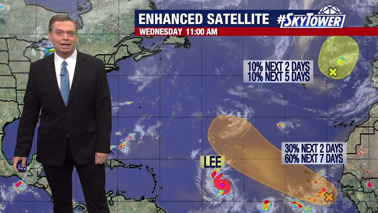
FOX 13 Meteorologist Jim Weber is keeping a close eye on Tropical Storm Lee, which is expected to strengthen into a major hurricane. The peak of hurricane season is four days away and he is seeing an uptick in tropical activity. In addition to Lee, Weber is watching Invest 96 working its way off the coast of Africa, and he is also monitoring the remnants of Hurricane Franklin, which may try to re-establish itself. Weber expects Tropical Storm Lee to reach hurricane strength soon and strengthen as it moves over warm water in the Atlantic. While Weber does not expect Lee to hit Florida because the computer models show it turning northward before reaching the Sunshine State, he says we could feel some of the effects depending on when it makes that turn.
FOX 13 Meteorologist Jim Weber is keeping a close eye on Tropical Storm Lee, which is expected to strengthen into a major hurricane. The peak of hurricane season is four days away and he is seeing an uptick in tropical activity. In addition to Lee, Weber is watching Invest 96 working its way off the coast of Africa, and he is also monitoring the remnants of Hurricane Franklin, which may try to re-establish itself. Weber expects Tropical Storm Lee to reach hurricane strength soon and strengthen as it moves over warm water in the Atlantic. While Weber does not expect Lee to hit Florida because the computer models show it turning northward before reaching the Sunshine State, he says we could feel some of the effects depending on when it makes that turn.