

Beware the 'I' storm: It has more retirees than any other letter used for Atlantic hurricane names
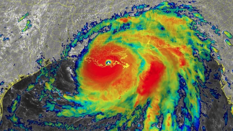
Infrared satellite image of Hurricane Ida after the storm made landfall in southeastern Louisiana on Sunday, Aug. 29, 2021. (NOAA/NESDIS/STAR)
Hurricane Ida crashed ashore in southeastern Louisiana on Aug. 29, 2021, with maximum sustained winds of around 150 mph, a Category 4 on the Saffir-Simpson Hurricane Wind Scale.
The storm produced a powerful 14-foot storm surge along the Louisiana coastline and dumped torrential rainfall across much of the northern Gulf Coast, but its impacts didn't stop there. The storm's effects were also felt up the entire Eastern Seaboard, where tornadoes and flooding were reported as north as New England.
Hurricane Ida was blamed for the deaths of more than 100 people, and its estimated damages topped $75 billion from the Caribbean to New England. The destruction was enough to propel the storm to the fifth-costliest hurricane in U.S. history, ranking just behind Katrina, Harvey, Maria and Sandy, respectively.
The World Meteorological Organization voted in April 2022 to retire the name "Ida" from future use in the Atlantic Basin.
A storm's name can be retired if its impacts were particularly destructive and/or deadly. This would avoid the use of Ida, for example, for a future Atlantic "I" storm that might not even become a hurricane or affect any land areas.
Interestingly, more storms starting with "I" have been retired than a name beginning with any other letter.
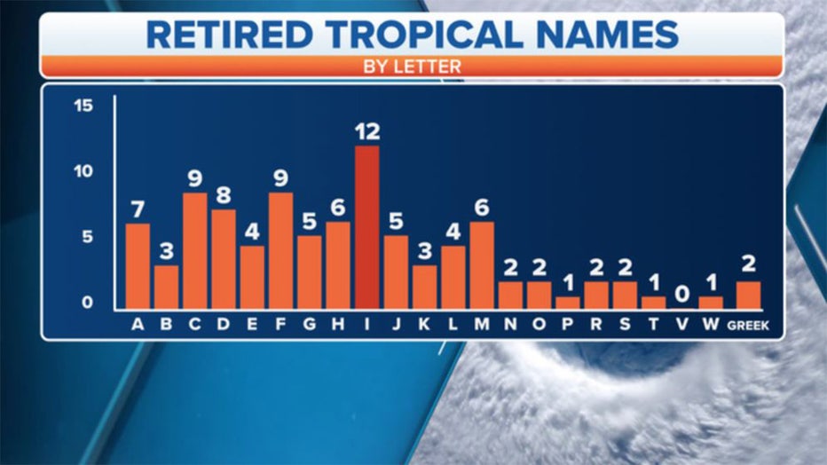
Retired tropical cyclone names by letter. (FOX Weather)
Since this retirement practice began in 1954, 12 "I" storms have been retired by the WMO. Tied for second place are "C" and "F" storms, each with nine retirees.
Ten of the 12 retired "I" storms have all occurred since 2001.
Retired "I" Tropical Cyclones
Ida - 2021
*Iota - 2020
Irma - 2017
Ingrid - 2013
Irene - 2011
Igor - 2010
Ike - 2008
Ivan - 2004
Isabel - 2003
Isidore - 2002
Iris - 2001
Inez - 1966
Ione - 1955
*From Greek alphabet alternative list
An average Atlantic hurricane season spawns 14 named storms, according to NOAA's most recent 30-year period of record (1991-2020). The "I" storm is the ninth of the season, so that means we can expect an "I" essentially every year.
Satellites began monitoring the entire Atlantic Basin in 1966, and 35 of the 55 hurricane seasons since then have reached the "I" storm, including Ida in 2021.
Based on data from NOAA and the National Hurricane Center, Sept. 18 was the average date the "I" storm formed in those 35 seasons. The earliest was June 28 (2020) and the latest was Oct. 13 (1999).
The mid-September period, when the "I" storm typically forms, is the peak of hurricane season. This is when environmental conditions tend to be most favorable for tropical cyclone development: water temperatures are at their highest across the Atlantic Ocean, Caribbean Sea and Gulf of Mexico; wind shear – the change in wind speed and direction with height that can rip apart developing tropical cyclones – is usually low; and tropical waves emerging off western Africa are often very robust.
When all of those conditions come into alignment, it's a "recipe" for strong hurricanes to develop and track hundreds of miles across the Atlantic Basin.
Unfortunately, the "I" storm just happens to come during this "recipe for disaster."'