

Antarctica's 'hummingbird' revealed in stunning new NASA radar
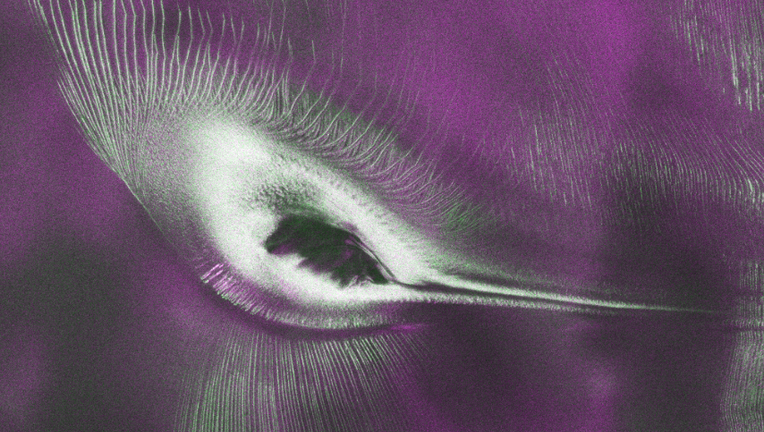
A new radar image captured by the NASA-ISRO Synthetic Aperture Radar (NISAR) satellite reveals an Antarctic landscape that resembles a hummingbird in flight. (Credit: NASA)
A striking new radar image captured by the NASA-ISRO Synthetic Aperture Radar (NISAR) satellite is turning heads for an unexpected reason: It looks remarkably like a hummingbird.
The colorful image, released by NASA this week, shows a rugged section of East Antarctica where a rocky mountain peak, known as Nunatak Zaterjavshijsja, rises through a flowing glacier.
While the scene resembles the silhouette of a bird in flight, it actually reveals a detailed view of fractured ice and glacier movement that scientists say showcases the capabilities of the new Earth-observing satellite.
RELATED: NASA’s Webb and Chile telescope discover faint new planet after 11-year cosmic hide-and-seek
What they're saying:
"First, it's a beautiful image, with rich details of features that provide insights to how the glacier is moving," said Seongsu Jeong, the signal analysis engineer at NASA's Jet Propulsion Laboratory who produced the image. "Then, because radar can often see through snow and deep into the ice, NISAR can observe fundamentally different properties of Antarctic ice than can be seen in optical imagery. With NISAR we're seeing what's hidden beneath the surface."

Declassified UFO file: Walter Cronkite interview with NASA astronaut Gordon Cooper
On June 12, the Pentagon released a third set of declassified files on what NASA calls Unidentified Anomalous Phenomena (UAP), commonly referred to as unidentified flying objects (UFOs).
Dig deeper:
The image was created using measurements collected by NISAR's L-band radar during early testing in August 2025. Unlike conventional satellite photography, radar can penetrate snow, ice and clouds, allowing scientists to reveal structures that optical satellites cannot see.
RELATED: Astronomers discover sugar in space, offering hints to life’s origins
In the image, the mountaintop disrupts the flow of the surrounding glacier, creating stress that fractures the ice into deep cracks known as crevasses. Those crevasses appear as vivid green streaks, while smoother ice surfaces appear magenta. White areas indicate a mix of both types of radar reflections.
Viewed with a traditional optical satellite, the same landscape appears almost entirely white, with only faint shadows hinting at the mountain and the uneven ice surrounding it.
NASA says the image highlights one of NISAR's biggest strengths: producing scientifically valuable data that is also visually striking.
Why you should care:
The release of the "hummingbird" image comes as NASA and the Indian Space Research Organisation (ISRO) begin making NISAR data publicly available.
Scientists expect the satellite to play a major role in tracking glacier movement, monitoring forests and wetlands, measuring land deformation, and helping researchers respond to natural hazards such as earthquakes and landslides.
Big picture view:
Launched on July 30, 2025, from India's Satish Dhawan Space Centre, NISAR is the first satellite to carry two synthetic aperture radar instruments operating at different wavelengths. Together, the instruments repeatedly map nearly all of Earth's land and ice-covered surfaces every 12 days, providing researchers with unprecedented detail about the changing planet.
The Source: The information in this story comes from NASA, including a news release and imagery from the agency's Jet Propulsion Laboratory (JPL). This story was reported from Los Angeles.