

National Hurricane Center tracks tropical wave entering Bay of Campeche
El Niño officially began on Thursday
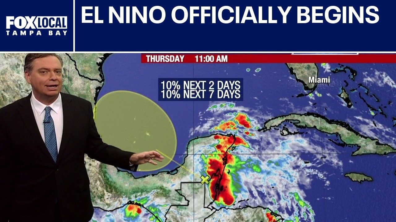
FOX 13 Meteorologist Jim Weber says El Nino officially started on Thursday, which usually means a quieter hurricane season. However, he is watching an area in the Southwestern Gulf that has a 10% chance of developing from the remnants of former Tropical Storm Cristina. Weber says it is unlikely it will develop because conditions aren’t favorable and there isn’t much time. Weber adds that it will work its way into Mexico. Otherwise, wind shear keeps the tropics quiet.
TAMPA, Fla. - A tropical wave tracking across the Yucatan Peninsula will push into the Bay of Campeche over the next couple of days, bringing a small chance of tropical development. The National Hurricane Center is monitoring the system, which is expected to stay far away from Florida.
Bay of Campeche system
What we know:
A tropical wave is currently tracking across the Yucatan Peninsula and will soon enter the Bay of Campeche. The system is made up of the remnants of Tropical Storm Cristina, which originally formed in the Pacific Ocean. Forecasters with the National Hurricane Center have given the wave a 10% chance of developing into a tropical system over the next seven days.
If it manages to organize into a tropical storm, it will take the name Arthur. Regardless of development, the system will likely act as a gusty rainmaker when it moves onshore along the coast of Mexico late Saturday or Sunday.
Any potential impacts from this system are expected to remain well away from Florida.

A SkyTower weather graphics map tracks a tropical disturbance near the Yucatan Peninsula and the Gulf of Mexico, which currently has a 10% chance of development over the next two to seven days.
Atlantic hurricane season
What we don't know:
Meteorologists cannot yet determine if this specific wave will find the right atmospheric conditions to overcome hostile upper-level winds and organize.
While the middle of June is typically when the Atlantic receives its first named storm, recent seasons have frequently started weeks before the average June 20 start date. It remains unclear exactly how active the rest of this year will become, though historical analog years with similar characteristics produced fewer named storms and hurricanes than an average season.

A climate data chart highlights Colorado State University's historical analog years to help meteorologists forecast the severity of the 2026 Atlantic hurricane season based on similar environmental conditions.
El Niño climate conditions
Why you should care:
The Climate Prediction Center confirmed that El Niño conditions are officially present in the Pacific.
Historically, El Niño leads to fewer named storms during the Atlantic hurricane seasons because it increases upper-level winds across parts of the Atlantic Basin. These hostile winds can disrupt tropical systems and prevent them from forming.
While these factors support the idea that overall activity may be lower this year, experts warn that it only takes one storm to make an impactful season. Quiet stretches of weather serve as an ideal time for families to review their hurricane plans and restock emergency supplies.
The Source: The information in this story was gathered from FOX 13 Meteorologist Nash Rhodes, the National Hurricane Center and the Climate Prediction Center, which detailed the tropical wave's path, development probabilities, and the official presence of El Niño conditions.