

Potential Tropical Cyclone 9 sets sights on Texas as several storms swirl in Atlantic

Tampa, Fla. - Texas is bracing for Potential Tropical Cyclone Nine as the tropics heat up.
The third tropical storm in two days developed on Monday.
Tropical Storm Gert formed early Monday morning, just a day after Tropical Storms Emily and Franklin organized and earned names.
As of 11 p.m. on Monday, Tropical Storm Gert was located at 17.1 degrees longitude and 58.4 degrees latitude. It had maximum sustained winds of about 30 miles per hour and was traveling west at nine miles an hour.
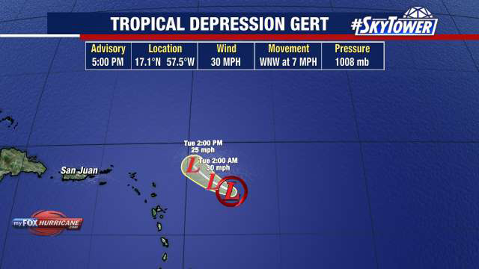
According to the National Hurricane Center, Tropical Storm Gert is expected to be short-lived and will quickly unravel.
STAY CONNECTED: Download the free FOX 13 News app for Live SkyTower Radar, forecast videos, and more weather coverage
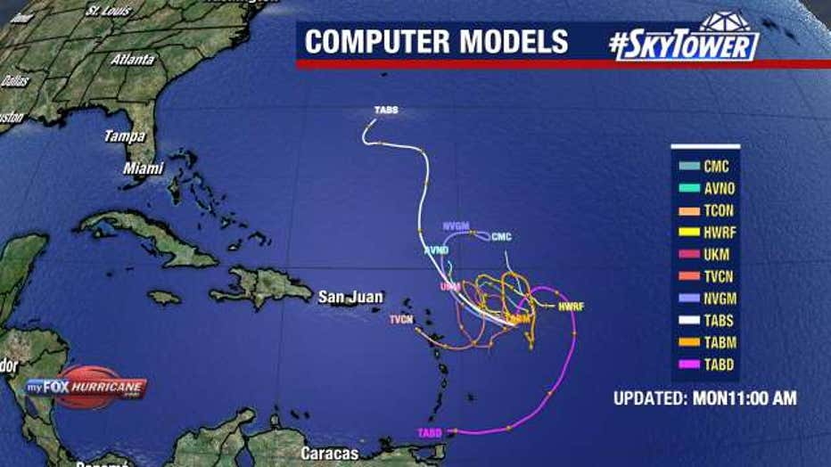
Computer models show Tropical Storm Gert staying out over open waters.
One day after developing, Tropical Storm Emily was downgraded Monday morning to a post-tropical cyclone. As of 11 a.m., Emily was located at 21.1 degrees longitude and 41. 9 degrees latitude.
Its maximum sustained winds were 35 miles an hour, and it was traveling west-northwest at nine miles an hour.
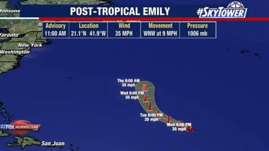
Emily was downgraded to a post tropical cyclone on Monday morning.
FOX 13 Meteorologist Jim Weber says like Tropical Storm Emily, Tropical Storm Gert will likely dissipate on Monday due to wind shear.
Tropical Storm Franklin is another story though.
Tropical Storm Franklin formed Sunday in the Caribbean. As of Monday afternoon, it was just south of Hispaniola, but it is expected to turn into the Atlantic and gain strength.
READ: Tropical Storm Hilary makes landfall in California as Mexico copes with its aftermath
Though the storm is not well organized yet, its winds have reached 50 miles per hour.
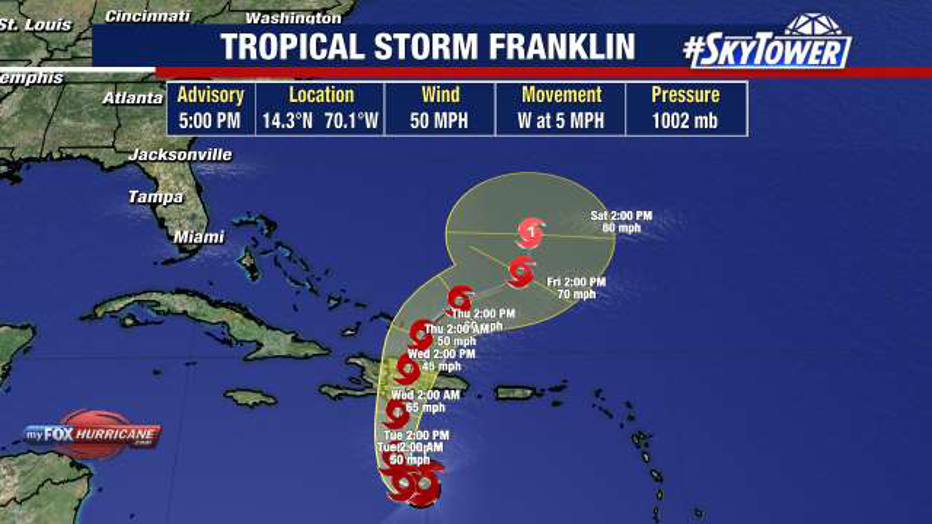
Tropical Storm Franklin had maximum sustained winds of 50 miles an hour as of 8 p.m. on Monday. It was located at 14.3 degrees longitude and 70.1 degrees latitude and was traveling west at six miles an hour.
Meteorologists say it will likely turn and move into the Atlantic.
READ: How to prepare for a hurricane
Once that happens, Tropical Storm Franklin will likely strengthen and may reach hurricane status.
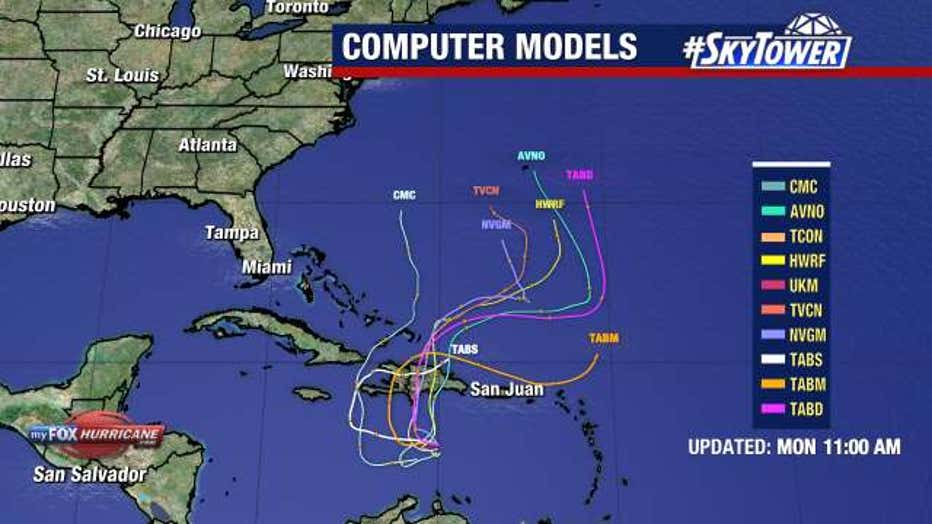
Computer models show Tropical Storm Franklin staying over open waters.
However, he expects the storm to remain over open waters and it will not impact Florida.
Potential Tropical Cyclone 9 dumped rain on Florida over the weekend and is now moving west in the Gulf of Mexico. While, FOX 13 Meteorologist Tony Sadiku expects Potential Tropical Cyclone 9 to gain strength, he does not see a well-defined center of circulation.
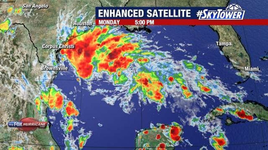
However, since it may become a tropical storm, the National Hurricane Center decided to call it Potential Tropical Cyclone 9 in order to post watches and warnings along the Texas coast. The system could impact Texas as early as Tuesday.
Sadiku says wind shear should prevent the system from rapidly intensifying, but it is expected to strengthen to the point where it earns a name.
Meteorologists are also watching a tropical wave off the coast of Africa that has a 40 percent chance of developing over the next two days and a 70 percent chance of developing over the next week.
Sadiku says none of the tropical systems he is watching will impact Florida.
The next named storm will be called Harold.
Stay up to date at www.MyFOXHurricane.com.