

Hurricane Idalia updates: Storm downgraded to Category 3 ahead of landfall

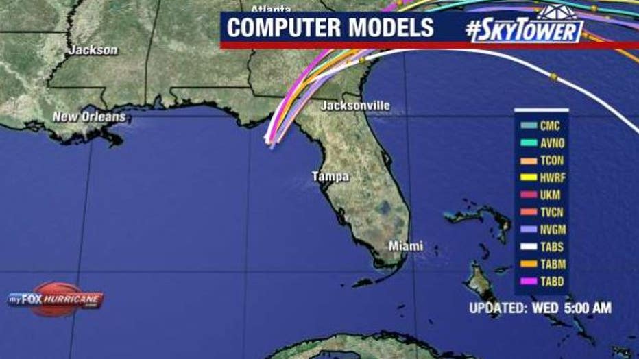
Hurricane Idalia: Wednesday morning track
Hurricane Idalia reached category 4 strength around 5 a.m. Wednesday ahead of a predicted landfall in the Big Bend Area.
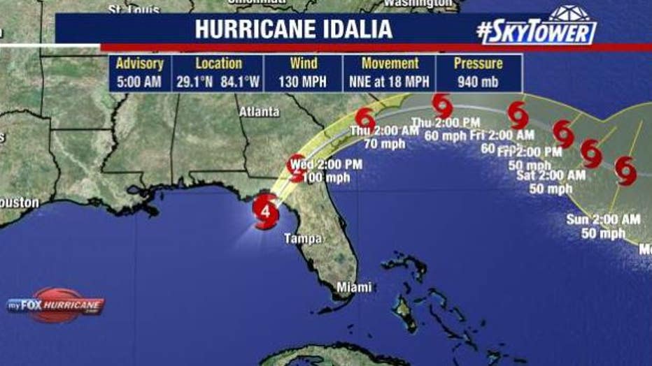
Tampa, Fla. - Hurricane became a Category 4 storm, which mean its winds topped 130 miles per hour around 5 a.m. on Wednesday and was downgraded to a Category 3 storm around 7 a.m. ahead of its predicted landfall in the Big Bend area of Florida.
As of 7 a.m. on Wednesday, Hurricane Idalia was located at 29.6 degrees longitude and 83.8 degrees latitude.
It had maximum sustained winds of 125 miles per hour and was moving north northeast at 18 miles an hour.
Hurricane Idalia timeline: What to expect as storm hits Florida
FOX 13 Meteorologist Dave Osterberg says though the storm has weakened a bit, it will still have a major impact on the Big Bend Area.
He says it is the strongest storm to ever enter this area of the Gulf of Mexico.
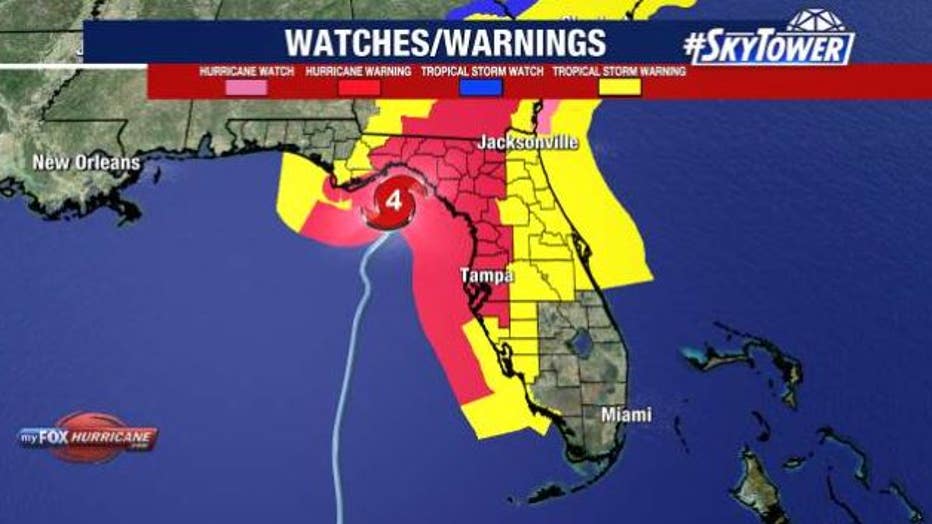
A hurricane warning is in effect for the middle of Longboat Key northward to Indian Pass, including Tampa Bay and a storm surge warning is in place for Englewood northward to Indian Pass, including Tampa Bay.
Osterberg says the rain and wind bands will continue to impact the Bay Area and they will move quickly. He does not believe we will see sustained winds and rain overnight.
Osterberg says the lightning that can be seen in the center of the storm is a sign it is intensifying. He expects it to intensify all the way until landfall.
Osterberg says the town of Steinhatchee, which is on the Steinhatchee River is going to be in the crosshairs of the storm. He says the town will likely get the maximum storm surge as Hurricane Idalia rolls up the Steinhatchee River because it is attached to the Gulf of Mexico.
According to Osterberg, the Cedar Key Hurricane of 1896 was the last time that area experienced a storm of this magnitude.
FOX 13 Meteorologist Tony Sadiku says when Hurricane Idalia strengthened on Wednesday, it also got larger. As of 5 a.m., the tropical storm force winds extended out 105 miles, and the hurricane force winds extended out 25 miles.
He says Hurricane Idalia will come ashore around Wakulla, Taylor and Jefferson Counties and then move north. According to Sadiku, it will weaken as it moves across land. It is still expected to be a hurricane it enters South Georgia.
Osterberg says waves heights in the northeast Gulf are topping 16–22 feet as of 5 a.m. on Wednesday.
Why Hurricane Idalia's landfall in Florida during full moon will increase storm surge threat
The Bay Area could see a storm surge of 4–6 feet with our northern counties experiencing a 7-11-foot storm surge.
Many residents in the Bay Area were under mandatory or voluntary evacuations ahead of the storm, which also closed schools, businesses and airports in the area.
Hurricane Idalia also knocked out power to several communities.
Coastal areas were also beginning to see flooding early Wednesday morning.
Road Closures
Hurricane Idalia also closed the Sunshine Skyway Bridge around 3 a.m. on Wednesday because winds reached 50 miles per hour. The Howard Frankland Bridge also shut down Wednesday morning due to water on the roadway.
Roosevelt Blvd. to Gandy Blvd. was also closed.
The eastbound lanes of the Courtney Campbell are also closed.
The three bridges are closed around Treasure Island as is the Cortez Bridge in Manatee County.
All access to Clearwater Beach is also closed -- even with barrier access permits. The city says residents can leave the beach, but people cannot get there via Memorial Causeway or Sand Key. Fire rescue crews say they are seeing flooding in beach areas and elsewhere in the city.
As of 5:30 a.m. on Wednesday, access to the following barrier islands has been closed to all citizens, including residents:
- Belleair Beach
- Belleair Shore
- Indian Rocks Beach
- Indian Shores
- Madeira Beach
- North Redington Beach
- Redington Beach
- Redington Shores
- St. Pete Beach
- Tierra Verde
- Treasure Island