

Tropical Storm Arthur forms in Gulf
Tropical Storm Arthur develops in Gulf
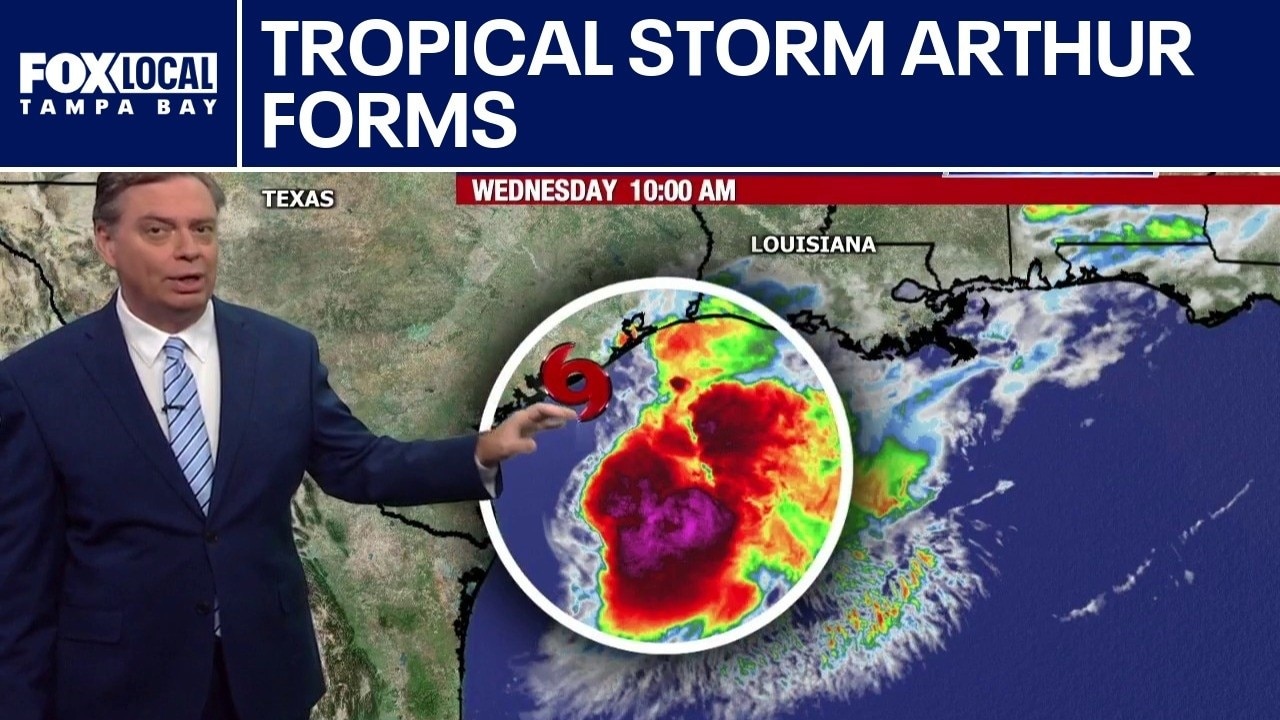
Tropical Storm Arthur, the first named storm of the 2026 hurricane season, formed Wednesday morning in the Gulf. FOX 13 Meteorologist Jim Weber says it is traveling along the Texas coast and notes that there is not a lot going on near the center of the storm. As it works its way northeast, Weber says the system will weaken as it makes its way back on shore. Tropical Storm Arthur had winds of 40 miles per hour as of 11 a.m., but he noted that the biggest threat with Arthur is the rain. The storm is expected to drop five to ten inches of rain with some locations getting 20 inches of rain. He added that it will impact a good portion of the Southeastern portion of the United States, including the Florida panhandle.
TAMPA, Fla. - The first tropical storm of the 2026 hurricane season formed in the Gulf on Wednesday.
Tropical Storm Arthur likely to form Wednesday
What we know:
Potential Tropical Cyclone One strengthened into Tropical Storm Arthur as an area of low pressure skirts along the coast of Texas.
As of 11 a.m. Tropical Storm Arthur was located at 28.6 degree longitude and 95.8 degrees latitude, which is about 190 miles southwest of Lake Charles, Louisiana.
It had maximum sustained winds of 40 miles per hour and was moving northeast at nine miles per hour.

Tropical Storm Watches and Warnings
Dig deeper:
A Tropical Storm Warning is in effect from High Island, Texas to Morgan City, Louisiana.
A Tropical Storm Watch is up from Sargent, Texas to High Island.
Tropical storm conditions are possible within the watch area and expected within the warning area later on Wednesday.
A Tropical Storm Warning means that tropical storm conditions are expected within the warning area, in this case within 12 to 24 hours.
A Tropical Storm Watch means that tropical storm conditions are possible within the watch area, in this case, within 12 hours.

Tropical Storm Warnings and Watches are issued along the Texas and Louisiana Gulf Coasts as a tropical disturbance triggers emergency coastal tracking protocols.
Rainfall, storm surge and swells
Why you should care:
The system is expected to dump five to 10 inches of rain, with isolated higher totals near 20 inches, through early Friday from the Mid and Upper Texas coast east-northeast into southern and central portions of Louisiana, Mississippi, and Alabama, along with western portions of Georgia and the Florida Panhandle.
According to the National Hurricane Center, this could cause dangerous to life-threatening flash flooding and a storm surge.

A coastal weather outlook warns of a potential 2-4 foot storm surge above ground level threatening areas from Galveston to Morgan City as a tropical system develops in the Gulf.
The combination of a dangerous storm surge and the tide will flood normally dry areas near the coast as rising waters move inland from the shoreline.
Swells generated by the storm are likely to cause life-threatening surf and rip current conditions along the northwestern Gulf Coast for the next couple of days.
Future storm developments
FOX 13 Meteorologist Dave Osterberg said Tropical Storm Arthur is being sheared apart, which keeps it from rapidly intensifying.
Osterberg said it will likely fall apart late on Wednesday or early Thursday morning.
Pensacola is expected to see several inches of rain, but aside from the Panhandle, Florida is not expected to experience the effects of the storm.
The Source: The information in this story was gathered from FOX 13 meteorologists and the National Hurricane Center, which provided detailed public weather advisories and track maps, as well as official tropical storm watches and warnings.