

Cold air settles in across Tampa Bay area with freeze warnings issued in most of the region

TAMPA, Fla. - Winter is coming. For most of Florida, it's already here.
The temperatures proved to be completely different from what they were Friday morning as the cold front moved through the Sunshine State. A bitter blast of arctic air charged its way across the U.S., dropping wind chills to as low as between negative 50 and negative 70 degrees before it arrived.
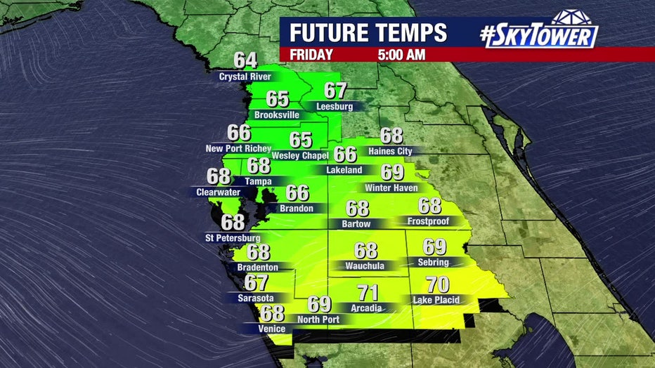
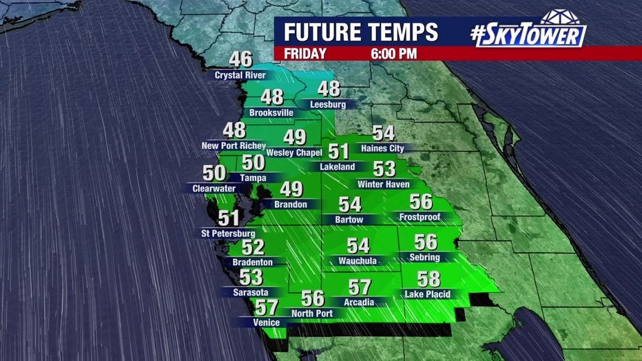
Friday started out in the 60s but will drop to the 50s by the evening time. That doesn't include the wind chill or feel-like temperatures.
COUNTY-BY-COUNTY LIST: Tampa Bay area counties open cold weather shelters with freeze warnings issued for Christmas weekend
Check out the difference between Friday morning compared to Saturday morning below:

"Wind chills at that point will be in the lower 40s or even colder than that," explained FOX 13's meteorologist Dave Osterberg.
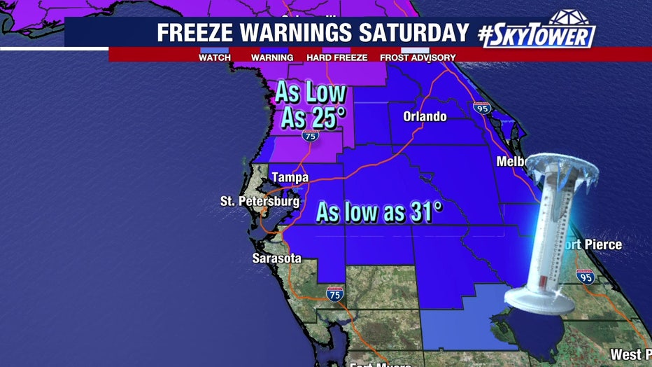
In anticipation of below-freezing temperatures, the National Weather Service has upgraded its hard freeze and freeze watches to warnings for much of the Tampa Bay area. And, there's now a wind chill advisory, too.
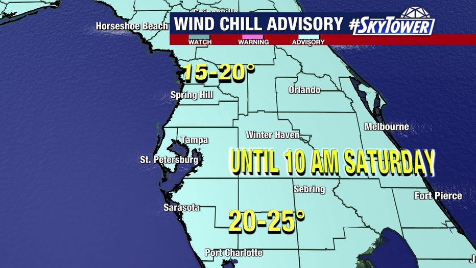
Wind chill advisories began Friday night for everyone in the Bay Area region. Osterberg said wind chill temperatures could reach 15-20 degrees for those in Citrus, Hernando and Pasco counties. In fact, those counties, including Sumter, have a hard freeze warning for tonight as well.
Meanwhile, the rest of the Bay Area – with the exception of Pinellas and Sarasota counties – is under a freeze warning. Osterberg said that although it doesn't include those two coastal counties, temperatures could still reach the mid-30s on Saturday morning.
For several towns and cities in Florida and the Southeast, it will likely be one of — if not the coldest Christmas Days on record, threatening the records set during the chilly Christmases of 1989 and 1983.
MORE: When do iguanas fall from trees in Florida (and will it happen on Christmas Day)?
For the Bay Area, it is forecast to be within the top three coldest Christmas days on record. By next week, temperatures will return to the 70s.
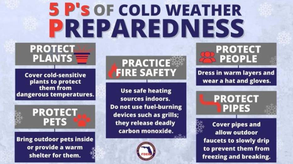
(Courtesy: Florida Department of Emergency Management)
Travel conditions are expected to become extremely difficult, if not impossible, in many of the areas covered by winter weather alerts due to the combination of snow, high winds and frigid wind chills.
According to the FOX Forecast Center, the highest snowfall totals along the path of this winter storm will likely be found in the western Great Lakes region. More than a foot of snow could pile up in parts of the Upper Peninsula of Michigan, western Lower Michigan and far northern Wisconsin.

Farmers watch crops during cold temperatures
With freeze warnings issued for most of the Tampa Bay area, strawberry farmers are doing what they can to protect their livelihood.
READ: Local strawberry farmers and gardeners preparing for cold weather
Storms around the country were already hammering travelers at Tampa International Airport this week. From Atlanta to Washington, holiday travelers are facing a wall of cancelations and delays with snow stopping many planes in their tracks.
"We were supposed to fly tomorrow," said Tom Goeltz of Ohio. "Then I called and switched it to today because of all the weather that’s coming into Cincinnati."
Airport officials said the number of travelers normally goes up by one-third during the holidays, often from 60,000 passengers a day to 80,000.
RELATED: When storms 'bomb out': Explaining how a bomb cyclone forms
The airport does say that extra staff, as usual, has been called in to handle longer lines at security, concessions and ticketing counters.
Airport officials certainly urge travelers to check flights before leaving home and to get to the airport a couple of hours early just to make sure there’s time to adjust flights or schedules.