

Nicole weakens into tropical depression as it moves over the Florida panhandle

VERO BEACH, Fla. - Tropical Storm Nicole officially weakened into a tropical depression as it makes its way over the Florida panhandle. The storm made landfall in the middle of the night as Hurricane Nicole near North Hutchinson Island, just south of Vero Beach.
The storm then quickly downgraded back to a tropical storm after landfall.
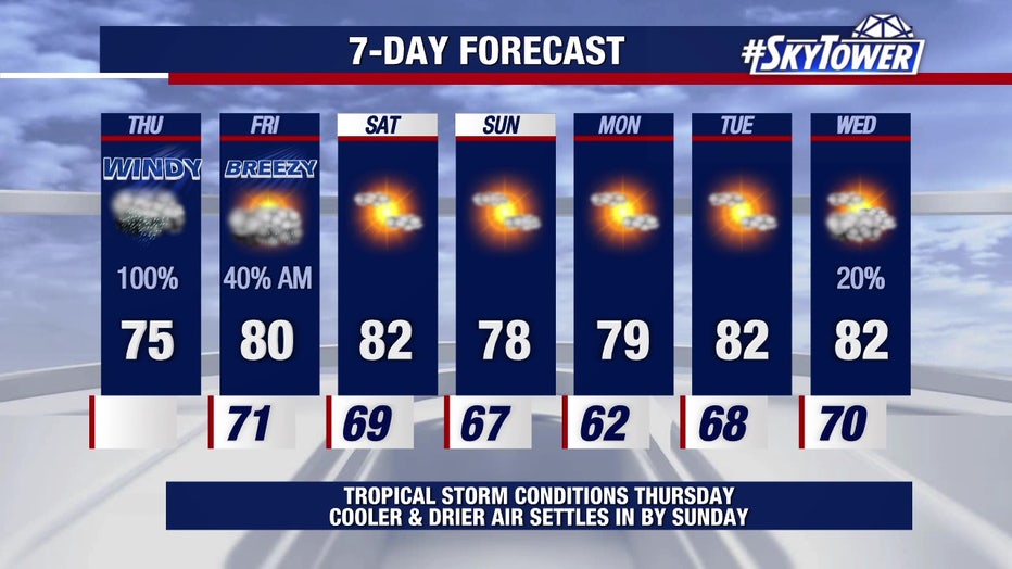
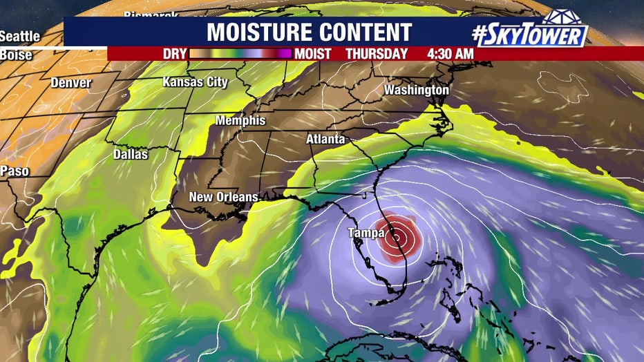
FOX 13 Chief Meteorologist Paul Dellegatto says Nicole had a decent circulation as of 4 p.m. on Thursday. As it moved away from the Bay Area, it was producing strong winds in the panhandle. However, he says Nicole will begin to pick up speed and move away, leaving us with improving weather.
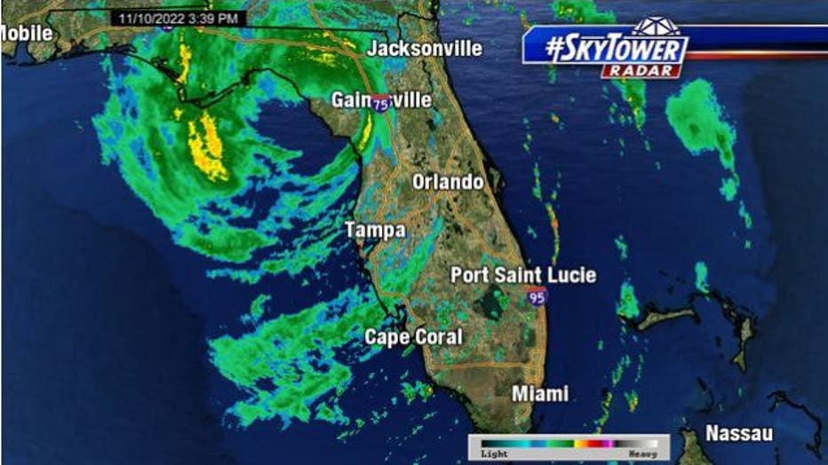
Radar view of Tropical Storm Nicole.
"This was barely a hurricane when it touched the coast," said FOX 13's meteorologist Dave Osterberg. "The second it moves onshore, it weakens. It's moving northwest. On a path like this, it's just going to continue to bring the wind and the rain across the state."
Before 5 a.m., its center was making its way to Orlando, meanwhile, heavy rain was dropping in the Cape Coral area. Polk County was feeling tropical storm-force wind gusts and the worst of the weather arrived before 9 a.m. in the Tampa area.

Nicole destroys Daytona Beach Shores hotel deck
Video from Nicole Huebener shows heavy damage done to the Dream Inn Daytona Beach Shores after Tropical Storm Nicole. Via Storyful
"Pretty much as expected, it was a rough morning," Dellegatto said.
Dellegatto stated that Nicole’s eye was so expansive that it helped reduce rainfall in Central Florida counties, but made for a rainy day across the Bay Area.
LINK: Track Nicole on MyFOXHurricane.com
Dellegatto says winds are still a factor, gusting 30-35 miles per hour as of 4 p.m., but he expects them to diminish tonight.

Drone video shows up-close view of damage to 60-year-old Florida pier partially swept away by Nicole
Drone video from WSVN shows an up-close view of the extensive damage to the nearly 60-year-old Anglins Fishing Pier in Lauderdale-By-The-Sea, which partially collapsed early Thursday morning when Nicole made landfall as a hurricane on Florida's east coast. The remaining portion of the pier suffered extensive damage.
Dellegatto says Nicole is the first hurricane to make landfall on the east coast of Florida since Katrina in 2005. It is also the latest hurricane on record to make landfall on the U.S. Atlantic coast. It is also the fourth hurricane on record to make landfall in the United States.
According to Dellegatto, it is also a ‘wacky coincidence’ that Hurricane Charley and Hurricane Jeanne were 43 days apart in 2004 while Hurricane Ian and Hurricane Nicole were 43 days a part in 2022.
How Nicole impacted the Bay Area
Shortly before 7 a.m., Florida troopers shut down the Sunshine Skyway Bridge due to high winds. Officials close the bridge when there are maximum sustained winds of 40 mph over it. FHP was reporting winds reaching 50 mph. The Sunshine Skyway reopened around 3:50 p.m.
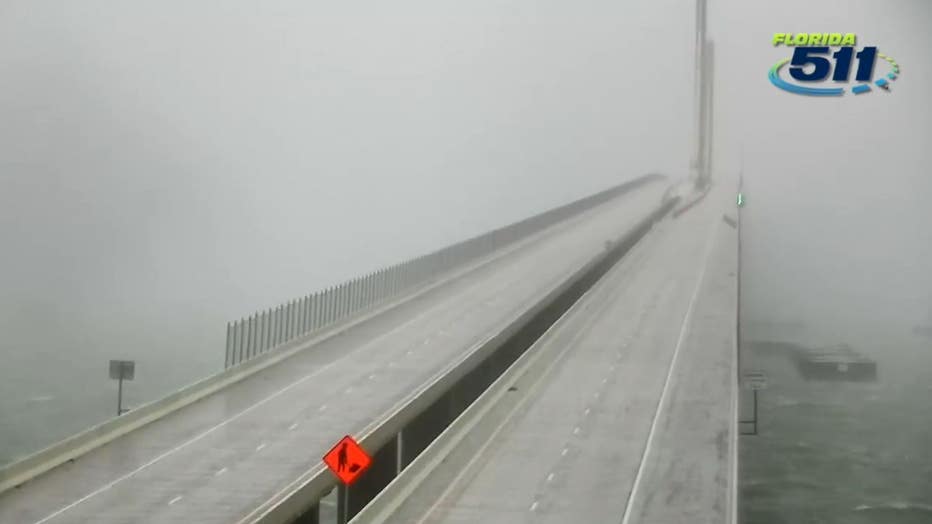
Screenshot from an FDOT camera shows an empty Skyway Bridge after officials closed it due to high winds.
Conditions are expected to improve in the Bay Area during the afternoon hours. Thursday night and into tomorrow, there could be a rain band or two that moves through the region. Nicole’s center is expected to move across central and northern Florida into southern Georgia on Thursday and into the evening, and into the Carolinas on Friday.

2 Daytona Beach hotels crumble into ocean during Tropical Storm Nicole
Drone footage recorded by Greg Walck captures the damage done by strong waves near the Hawaiian Inn Beach Resort and Ocean Court Motel due to Storm Nicole, as structures are seen collapsed and large pieces of debris litter the surroundings. COURTESY: Greg Walck via Storyful
By this evening, it will drop below tropical storm-force winds. There may be some nuisance flooding as it moves across the state.
Once the storm moves to our northwest, the winds are going to shift to the southwest.
"Keep that in mind in the Tampa Bay area because we have a high tide at about 4:30 p.m. Initially the water was being pulled out, right? It's going to be pulled back in at about 3-4 p.m.," Osterberg described. "As it's gone later tonight and tomorrow, we'll get a leftover shower tomorrow, and then we're done. Then, the weekend weather looks nice."
How can I check power outages in my area?
Over 300,000 people were without power as of Thursday morning.
You can monitor outages on each power company's website:
- Duke Energy - https://outagemap.duke-energy.com/#/current-outages/fl
- Florida Power & Light - https://www.fplmaps.com/
- Peace River Electric - https://www.preco.coop/services/outage-center/
- TECO - https://account.tecoenergy.com/outage/outagemap
- Lakeland Electric - https://lakelandelectric.com/storms-and-outages
- Withlacoochee River Electric - https://staticmap.wrec.net/
How Nicole impacted areas outside the Tampa Bay region

Authorities warned that Nicole’s storm surge could further erode many beaches hit by Hurricane Ian in September. The sprawling storm is then forecast to head into Georgia and the Carolinas later Thursday and Friday, dumping heavy rain across the region.
A few tornadoes will be possible through early Thursday across east-central to northeast Florida, the weather service said. Flash and urban flooding will be possible, along with renewed river rises on the St. Johns River, across the Florida Peninsula on Thursday.

Hurricane Nicole: Weather tourists on Indialantic Beach in Melbourne, Florida
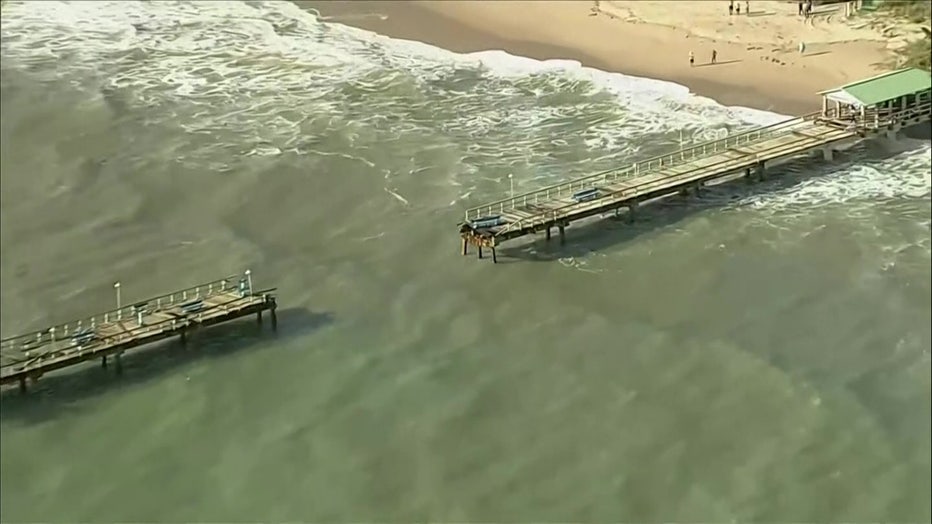
Ahead of Hurricane Nicole, several people scurried to the beaches near Melbourne, Florida on the state's east coast to sway in the winds and take in the waves. Experts and emergency personnel say to stay away from the ocean in conditions like this.
There were reports of 22-25 feet of waves off the coast of Jacksonville.
Over in Broward County, the Lauderdale-by-the-Sea pier was split in half. Its wooden planks were ripped off and the center of it fell into the ocean.
View of the Lauderdale-by-the-Sea pier after Nicole
Heavy rainfall from this system will spread northward across portions of the southeast, eastern Ohio Valley, Mid-Atlantic, and New England through Saturday.
Nicole became a hurricane Wednesday evening as it slammed into Grand Bahama Island, having made landfall just hours earlier on Great Abaco island as a tropical storm with maximum sustained winds of 70 mph. It is the first storm to hit the Bahamas since Hurricane Dorian, a Category 5 storm that devastated the archipelago in 2019.
Florida counties battered by Ian brace for Nicole
In Wauchula, residents braced for Nicole after being battered by Hurricane Ian. Hurricane Ian left behind extensive damage when it struck in September. For Doyle Staton, he and his family are trying to get back to the north after flooding from Ian displaced them. Their home was under about two feet of water.
With Nicole, the family said they're as ready as they can be with sandbags and securing anything on the property that could blow away in high winds.
"Anything can happen, you could get a tornado out of this, and the whole house be gone, but by the grace of God, we’ll slip through this one too," Staton told FOX 13. "We’re not looking forward to it, actually it aggravated us a little bit, ya know, 30 days, and here comes another one."
Families in Sarasota and Manatee counties were nervous about Nicole's wind and rain. The restaurant, Silver Start East in Myakka City, said it's ready to serve its community after Nicole. Customers already stopped by for a break Wednesday after preparing their homes.

Local restaurant stays open for community
People in Manatee County said they're nervous of what wind and rain from Tropical Storm Nicole could do to their properties that are already damaged from Hurricane Ian.
READ: Manatee County restaurant to stay open for the community when Nicole moves through
"People are feeling tired and nervous," explained Antoinette Sapp, owner of the restaurant. "They're worried about the roofs that are leaking. Some of them don't even have tarps up right now, They're worried about flooding. They're worried about the river."
Sapp was open Thursday morning for anyone who needed refuge from the storm.
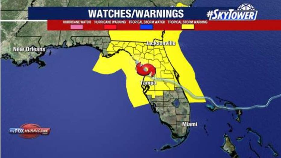
Tropical Storm Nicole watches and warnings.
RELATED: When was the last time a hurricane made landfall on Florida's east coast in November? 1935
The rare November hurricane had already led officials to shut down airports and theme parks – like Busch Gardens – and forced evacuations that included former President Donald Trump’s Mar-a-Lago club.
Dozens and dozens of flights were delayed or canceled for Thursday over the Tampa International Airport. Travelers can monitor their flight status at the TPA website or monitor through their airline's apps.
"It's wet. It's going to be raining on and off almost all day," Osterberg said. "The impacts in general shouldn't be all that bad. We are going to have some ponding on the roads, perhaps some minor flooding, we are going to have a few tree limbs down, no doubt, when we are talking about 40-45 mph wind gusts."
Check your county's status: Tropical Storm Nicole closures, sandbags, storm information for Tampa Bay area