

Heavy rain expected in South Florida as tropical system makes its way over Florida

TAMPA, Fla. - While the heaviest rain is expected to be in South Florida, parts of the Bay Area could see plenty of rain as a tropical system makes its way over the state.
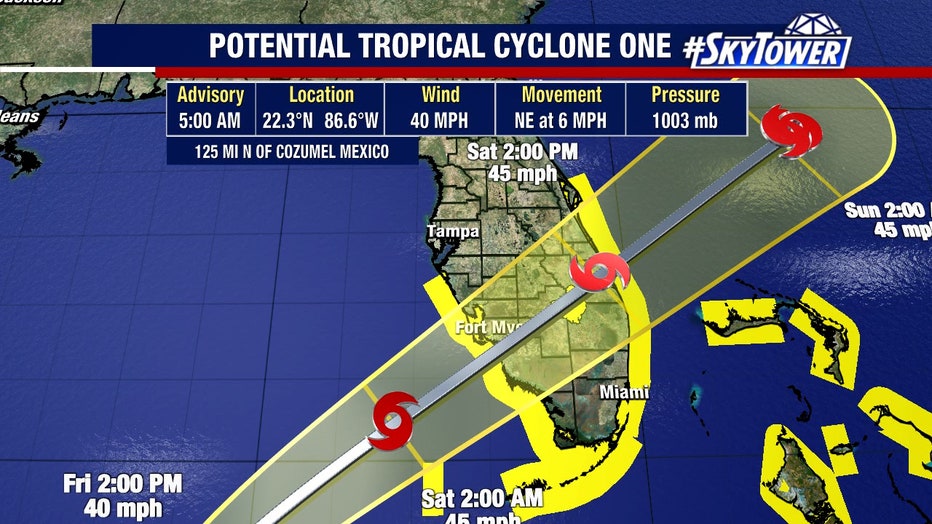
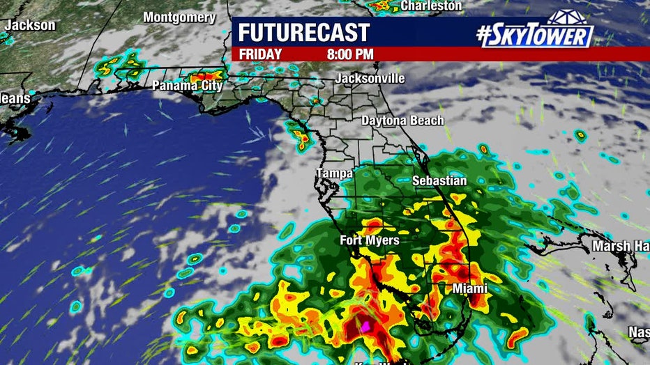
In general, residents from Sarasota and Highlands counties to Hillsborough and Polk counties will see most of the rain and some gusty winds from Potential Tropical Cyclone One beginning early Friday evening into Saturday.
"You got to understand with a system like this which is being incredibly sheared, just about all of the activity is going to be on the eastern side because that is where the wind is pushing it," explained FOX 13 meteorologist Dave Osterberg. "So, even as it moves onshore, say, the Fort Myers area, the showers are beginning to move north and they are getting up into Polk County, all of a sudden everything is being pushed to the eastern side, so this rain isn’t wrapping around a center. That is why you’re not getting a tremendous amount of rain back along the coast of Tampa or St. Petersburg."
LINK: Track the tropics on MyFOXHurricane.com
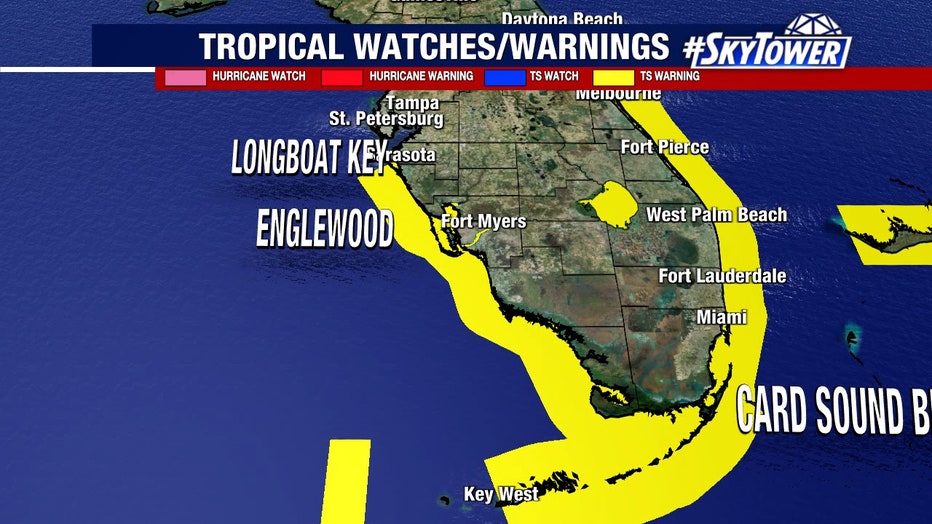
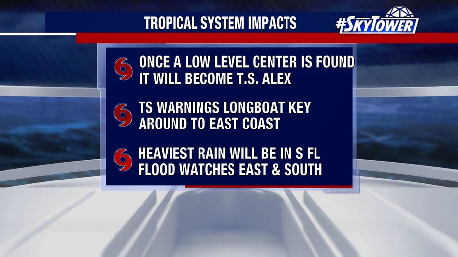
Tropical Storm Warning is in effect for:
- Florida Keys including the Dry Tortugas
- Florida Bay
- West coast of Florida south of the Middle of Longboat Key to Card Sound Bridge
- East coast of Florida south of the Volusia/Brevard County Line to Card Sound Bridge
- Lake Okeechobee
- Cuban provinces of Pinar del Rio, Artemisa, La Habana, and Mayabeque
- Northwestern Bahamas
READ: Potential Tropical Cyclone One timing, impact: Heavy rain expected around Tampa Bay starting Friday
"If there’s going to be any flooding, it’s likely going to be late tonight into tomorrow morning, south," Osterberg said. "I mean south of Highlands County, going into the Lake Okeechobee area."
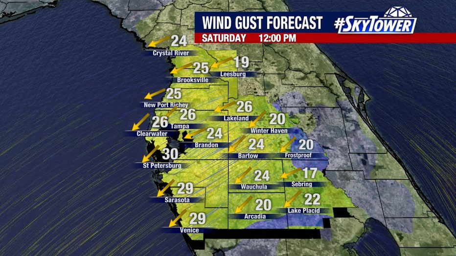
Wind will not be a big concern, he added, it’s just going to be the amount of rain.
"Once this low-level center is found, it will become Tropical Storm Alex. It won’t change the forecast. It just changes its name," he said, adding that it may take on that new name by late Friday.
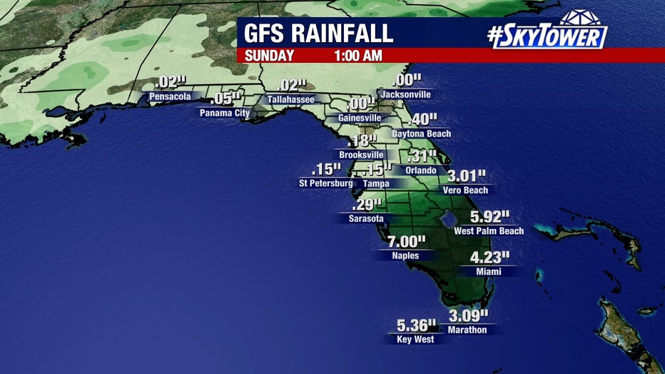
The National Hurricane Center predicts that rainfall up to 10 inches is possible in places in South Florida from this storm, which is not expected to produce huge winds or major storm surge. Still, flooding is likely and winds could be somewhat strong.
"It’s going to be one big wet mess," Osterberg said.
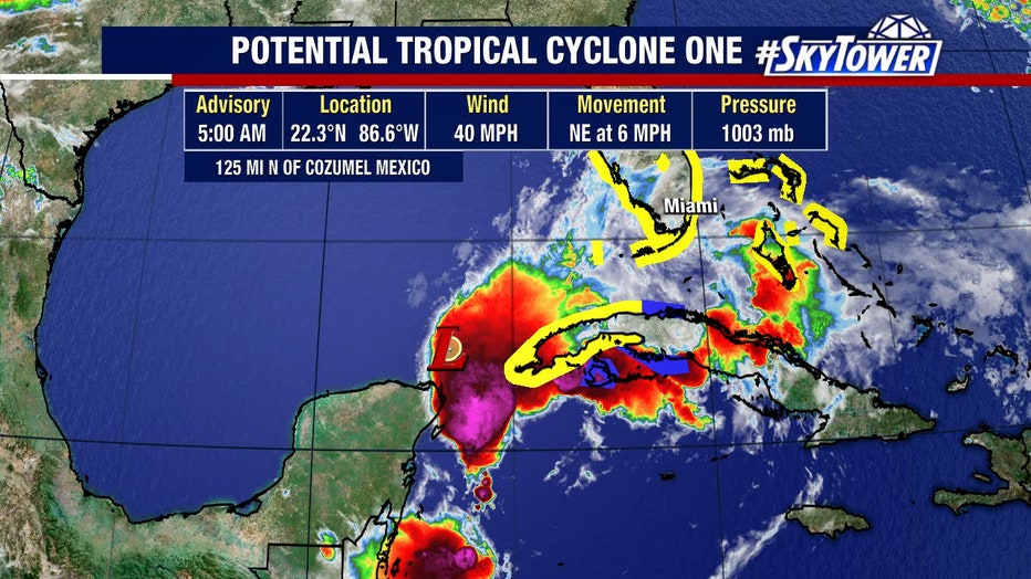
The Hurricane Center said maximum sustained winds from the system as of Thursday afternoon were about 35 mph with higher gusts. It’s expected to become a tropical storm sometime Friday, which means higher winds but not at hurricane levels.
"Heavy rains will begin to affect South Florida and the Keys Friday and continue through Saturday," the Hurricane Center said in an online post. Also predicted is storm surge and flooding, the severity of which depends on the timing of tides.
As a Pacific storm, Hurricane Agatha caused flooding and mudslides that killed at least 11 people and left 20 missing in Mexico, officials said. It caused rivers to overflow their banks and swept away people in homes, while other victims were buried under mud and rocks.
Now, the storm is headed for Florida.
Agatha made history as the strongest hurricane ever recorded to come ashore in May during the eastern Pacific hurricane season since 1949. Climate scientists say tropical systems will become more powerful and destructive because of global warming.
The Associated Press contributed to this report