

NOAA maps show street-by-street views of Hurricane Ian's destruction
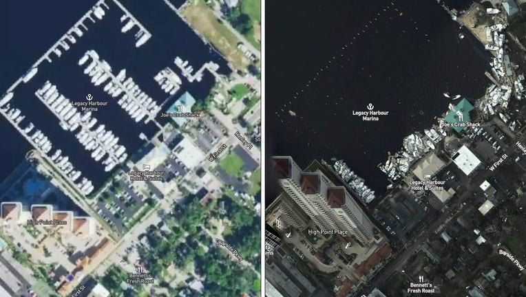
Thursday's view of a marina in downtown Fort Myers, contrasted with a photo from before Hurricane Ian. (NOAA)
We’ve already seen the frightening scenes that Hurricane Ian brought to southwest Florida, but the full extent of the storm’s impact is becoming more detailed now that the federal government is publishing aerial photos taken during recent survey flights.
Imagery posted on an interactive map was taken by NOAA’s Remote Sensing Division "to support homeland security and emergency response needs" after the storm. The photos – taken during long sweeps by the agency's Hawker Beechcraft King Air 350CER plane starting on Thursday – cover a 50-mile swath from Cayo Costa, where the storm’s eye made landfall, down to Sanibel and then up the Caloosahatchee River to Fort Myers.
A second 15-mile stretch covers the coast west of Cape Coral.
LINK: See NOAA's damage map
One of the most obvious features visible in the photos is the destruction of the Sanibel Causeway. Two sections of the span are entirely gone, but the imagery also shows just much sand and debris is covering what remains of the causeway.
Further west, many resorts and homes along Captiva Island appear to be inundated with sand and water, while some boats can be seen up along the shore.
Photos show the Sanibel Lighthouse is still standing, though it’s not yet clear if it was damaged.
Up the Caloosahatchee, damage to Fort Myers is clear. Boats in the Legacy Harbor Marina were tossed ashore; the nearby City Yacht Basin fared slightly better.
NOAA says the website will be updated as more flights take place.
Hurricane Ian made landfall Wednesday as a powerful Category 4 storm with 150-mph winds and a 12-foot storm surge. Several deaths have been blamed on the storm and rescues are still taking place.
Ian has regained hurricane strength in the Atlantic and is expected to make a second landfall Friday night in South Carolina.
NOAA’s interactive damage map can be found at https://storms.ngs.noaa.gov/storms/ian/index.html. Note that it may be easier to navigate the site from a desktop computer instead of a mobile device. More details: https://storms.ngs.noaa.gov/
This story was reported from Tampa, Fla.