

Hurricane warning issued for portion of Florida's east coast as Isaias' track shifts slightly west

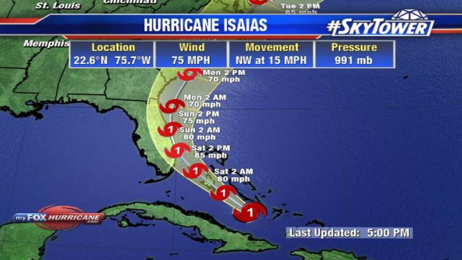
TAMPA, Fla. - Despite battling some higher wind shear, Hurricane Isaias continues to hang onto its Category 1 status in the 11 a.m. update from the National Hurricane Center.
On Friday morning, Hurricane Hunters noticed some weakening in the storm's strength as the southwesterly shear takes a bit of a toll on the structure of the storm, says FOX 13's chief meteorologist Paul Dellegatto.
A weaker storm would mean its track will shift west. Whereas a stronger storm means it will likely remain east of the state, which places Tampa Bay on the weaker and drier side.
Isais upgraded to a Category 1 storm late Thursday night. If it stays on its current projected track, the NHC says there is a small chance of tropical-storm-force winds in west-central and southwest Florida. The center of the storm could come close to the eastern side of Florida's coast.
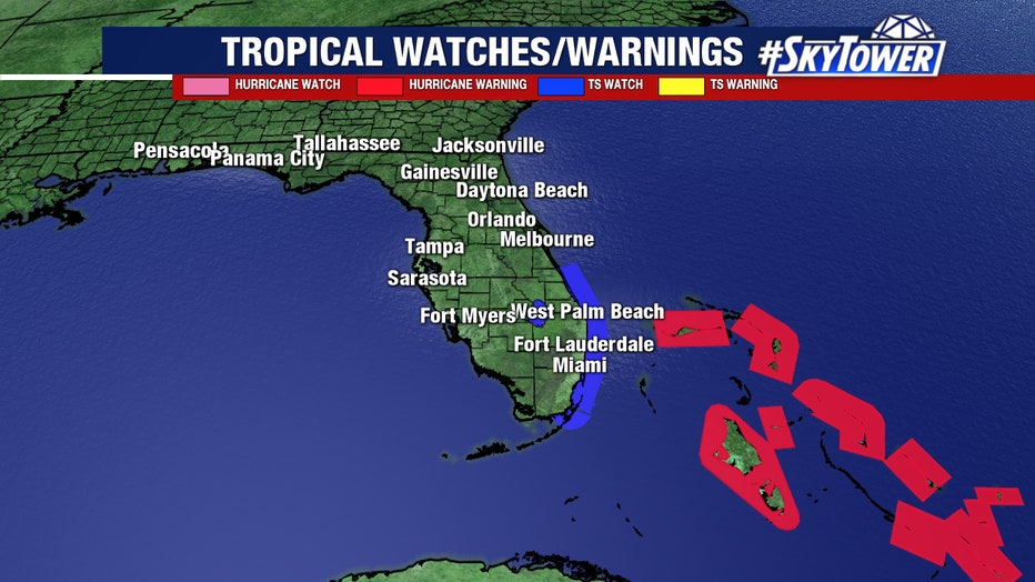
Forecasters declared a hurricane watch for parts of the Florida coastline on Friday as Hurricane Isaias drenched the Bahamas on a track for the U.S. East Coast.
A Hurricane Watch has been issued north of Deerfield Beach to the Volusia-Brevard County Line.
A Tropical Storm Warning is in effect for:
- Turks and Caicos Islands
- North of Ocean Reef northward to Sebastian Inlet
- Lake Okeechobee
In Polk County, sandbag sites opened Friday for residents.
Officials in Florida said they were closing beaches, marinas and parks in Miami-Dade County beginning Friday night. Mayor Carlos Gimenez said the county has 20 evacuation centers on standby that could be set up with COVID-19 safety measures.
“We still don’t think there is a need to open shelters for this storm but they are ready,” he said.
LINK: Head to MyFOXHurricane.com for ongoing updates
Isaias had maximum sustained winds of 75 mph (120 kph) Friday morning and it was expected to remain a hurricane for the next few days, according to the U.S. National Hurricane Center in Miami. It was centered about 295 miles (470 kilometers) southeast of Nassau in the Bahamas and was moving northwest at 16 mph (26 kph).
The Hurricane Center said heavy rains associated with the storm “may begin to affect South and east-Central Florida beginning late Friday night, and the eastern Carolinas by early next week, potentially resulting in isolated flash and urban flooding, especially in low-lying and poorly drained areas.”
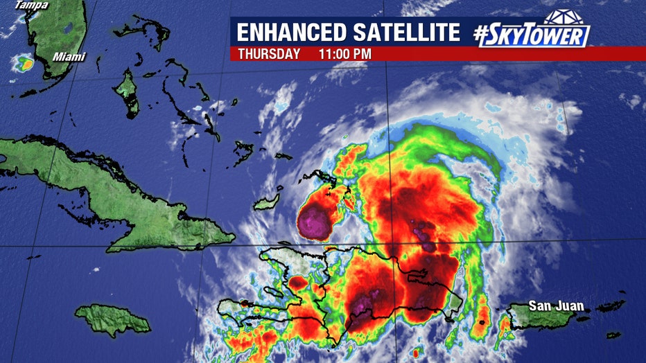
On Thursday while still a tropical storm, Isaias knocked out power, toppled trees and caused widespread flooding and small landslides in the Dominican Republic and Puerto Rico, where at least 35 people were rescued from floodwaters and one person remained missing. Hundreds of thousands of people in Puerto Rico were left without power and water.
A hurricane warning was in effect for the northwestern Bahamas, including Andros Island, New Providence, Eleuthera, Abaco Islands, Berry Islands, Grand Bahama and Bimini.
Two of those islands, Abaco and Grand Bahama, were battered by Dorian, a Category 5 storm that hovered over the area for two days and killed at least 70 people, with more than 280 reported missing. People are still living in tents on both islands, and officials said crews were trying to remove leftover debris ahead of Isaias.
Prime Minister Hubert Minnis announced late Thursday that he was relaxing a coronavirus lockdown as a result of the impending storm, but said a 10 p.m. to 5 a.m. curfew would be implemented starting Friday. He said supermarkets, pharmacies, gas stations and hardware stores would be allowed to be open as long as weather permitted.
“These are especially difficult days,” he said during an online news conference. “We need at this time the spirit of love and unity.”
The Associated Press contributed to this report