

More heavy rain, strong storms possible Tuesday as Invest 93L moves across Florida

Tampa weather | More storms Tuesday
FOX 13 Meteorologist Dave Osterberg says Tuesday will bring more rain and storms as Invest 93L moves across the state.
TAMPA, Fla. - A potential tropical disturbance dubbed Invest 93L will continue bringing heavy rain and strong storms to the Tampa Bay area as it moves west over Florida on Tuesday.
FOX 13 meteorologists say some areas saw multiple inches of rain on Monday, with 6–9 inches falling just south of Plant City.
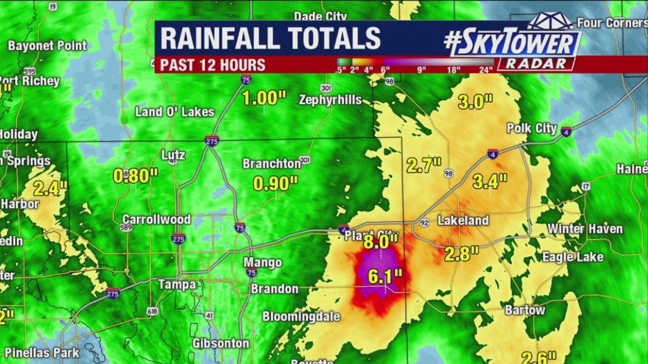
Several inches of rain fell in the Plant City area on Monday.
READ: Severe storms leave behind damage after rolling through parts of Tampa Bay area
Tuesday weather forecast
Timeline:
FOX 13 Meteorologist Dave Osterberg says Tuesday's timeline for rain could be similar to Monday's, with the strongest storms moving through the region during the afternoon and evening hours.
"We're right back at it again with that slight chance for excessive rain – potentially more flooding this afternoon," Osterberg said. "We should be fine until we get to about 2:00 or 3:00, and then going into the evening hours you start to see the showers and storms take over."
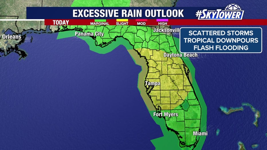
The Tampa Bay area faces a slight risk of excessive rain on Tuesday, meteorologists say.
Will Invest 93L develop?
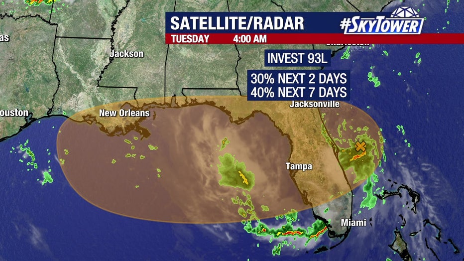
The National Hurricane Center is giving Invest 93L a 40% chance of development in the next seven days.
The National Hurricane Center is giving Invest 93L a 40% chance of development in the next seven days.
The NHC says the area of low pressure is slowly becoming more defined, but shower and thunderstorm activity remains disorganized as of Tuesday morning.
Most computer models show Invest 93L moving west over the Gulf, where it could develop into a tropical depression or tropical storm before turning north and moving over land.
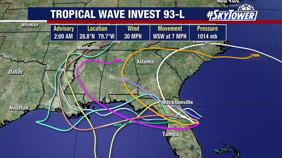
The NHC says Invest 93L could develop over the northern Gulf before moving over land.
"With a path like that, that would keep it relatively weak," Osterberg said. "But rainfall will be the dominant issue with this."
What to expect later this week
What's next:
Rain chances will remain high in the coming days, Osterberg says, with 70% coverage on Wednesday and Thursday before a gradual drop, which will also lead to normal summer temperatures again.
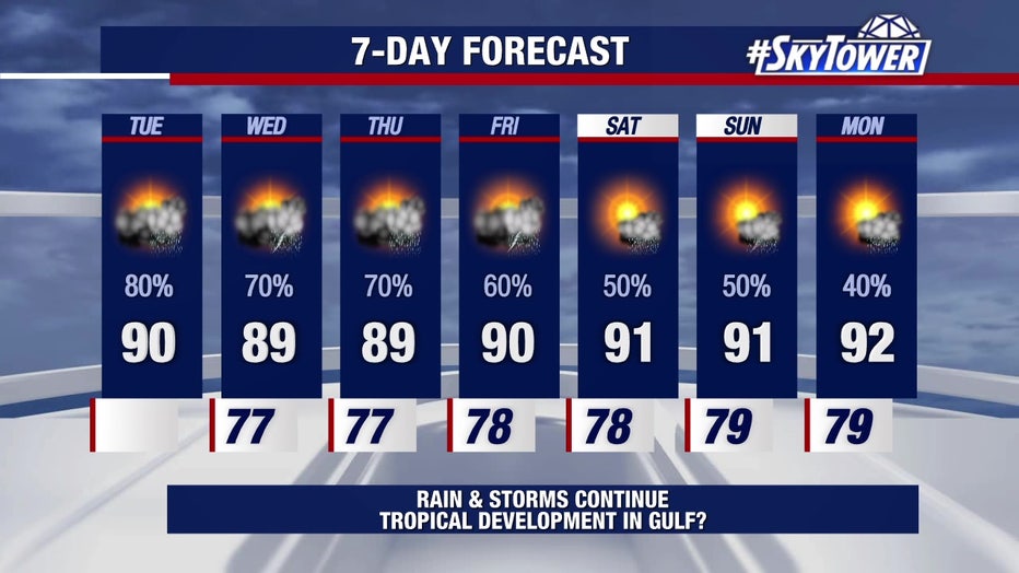
Rain coverage will gradually drop later this week and into the weekend, meteorologists say.
The Source: This story was written with information from FOX 13 meteorologists and the National Hurricane Center.