Tropical storm warnings canceled for most of Florida; heavy rain still expected in Bay Area

Tropical weather forecast Friday night update
The forecast track continued to move Tropical Depression Fred off Florida’s coast Saturday, keeping Bay Area counties out of the cone of uncertainty.
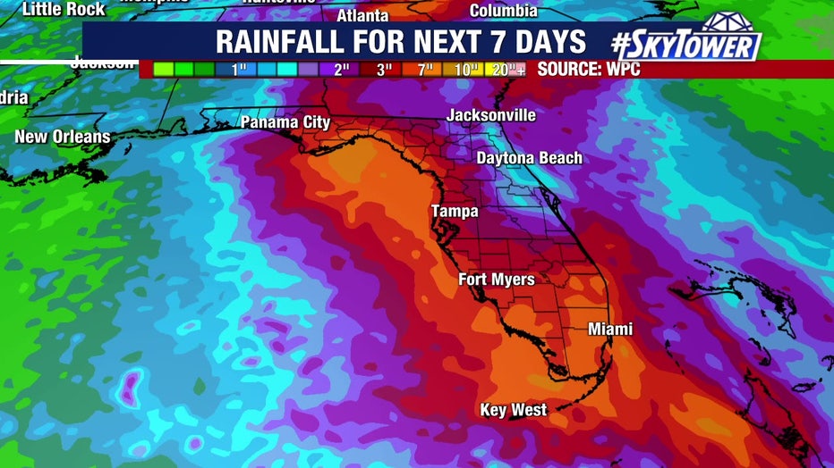
TAMPA, Fla. - The current forecast track for Tropical Depression Fred keeps the storm off the Bay Area's coast from Saturday into Sunday. Even though it's expected to regain tropical storm status, heavy rain will still be the biggest impact to the Bay Area.
"You ever have one of those Sundays where it’s just rainy and kind of windy all day long? I think that’s what this Sunday is going to be," said FOX 13’s meteorologist Dave Osterberg.
Watches and warnings have been issued ahead of Tropical Storm Fred's arrival in Florida. A tropical storm warning is in effect for the Florida Keys west of the Seven Mile Bridge to the Dry Tortugas.
The Tropical Storm Watch along the west coast of Florida was discontinued in the National Hurricane Center's 11 p.m. update Friday.
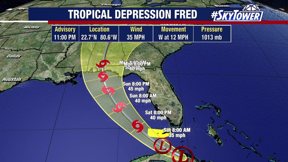
For the most part, based on the forecast track by the National Hurricane Center, Saturday will be a relatively quiet day until late in the afternoon and into the evening.
LINK: Track Fred on MyFoxHurricane.com
As of the 11 p.m. update, the forecast track shifted farther west, with the Florida peninsula out of the cone of uncertainty.
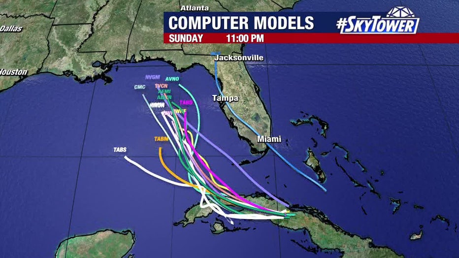
That does not mean Florida will escape the effects of the storm.
"It should be noted that much of the Florida peninsula is expected to be on the east side of Fred, which is where the heaviest rains, strongest winds, and a chance of tornadoes will be," the NHC advised.
"Now, maybe the storm moves 50 miles west and it changes a little bit but right now it does look like Sunday is going to be kind of a mess," Osterberg agreed. "It’s going to be rain, some of it coming down heavy at times. That will be the dominant issue around here, folks."
MORE: Tropical Depression Fred: Sandbag distribution around Tampa Bay
As far as the wind, onshore communities may see 25-30 mph winds.
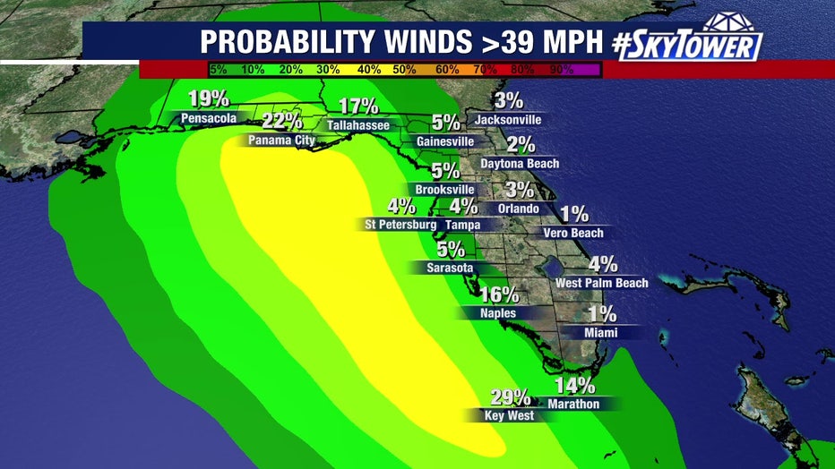
"The core of the winds will stay will offshore," Osterberg said. "Given the fact that so many places have seen a lot of rain already this week, it’s not going to take much to tip that balance and to cause a little bit of flooding. If you live in a flood-prone area, or next to a river that’s already at bank-full, I really need you to keep an eye out for things Saturday night and Sunday."
LINK: Track Fred on MyFoxHurricane.com
By Monday, he said the usual pattern of afternoon thunderstorms will resume.
Fred became the sixth of the Atlantic hurricane season late Tuesday as it moved past the U.S. Virgin Islands and Puerto Rico on a forecast track that would carry it toward Florida over the weekend.
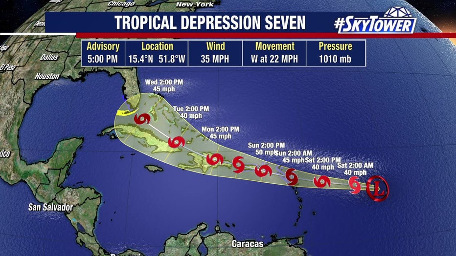
Meanwhile, further out into the Atlantic, Tropical Depression 7 formed on what may be a similar initial path as Fred. The NHC has started issuing advisories on what is expected to become Tropical Storm Grace as soon as tomorrow morning, bringing rain and wind to the Leeward Islands as it moves west.

