


Slight chance of development in Caribbean Sea
As hurricane season comes to an end Valerie Mills says a system in the far southern Caribbean Sea only has a 30% chance of additional development over the next week.
As hurricane season comes to an end Valerie Mills says a system in the far southern Caribbean Sea only has a 30% chance of additional development over the next week.

Tropics forecast includes small wave with light chance of development
Meteorologist Valerie Mills takes a look at our tropics forecast as the hurricane season approaches its close at the end of the month, with a small wave with a light chance of development.
Meteorologist Valerie Mills takes a look at our tropics forecast as the hurricane season approaches its close at the end of the month, with a small wave with a light chance of development.

Tropics remain quiet with no development expected in the coming week
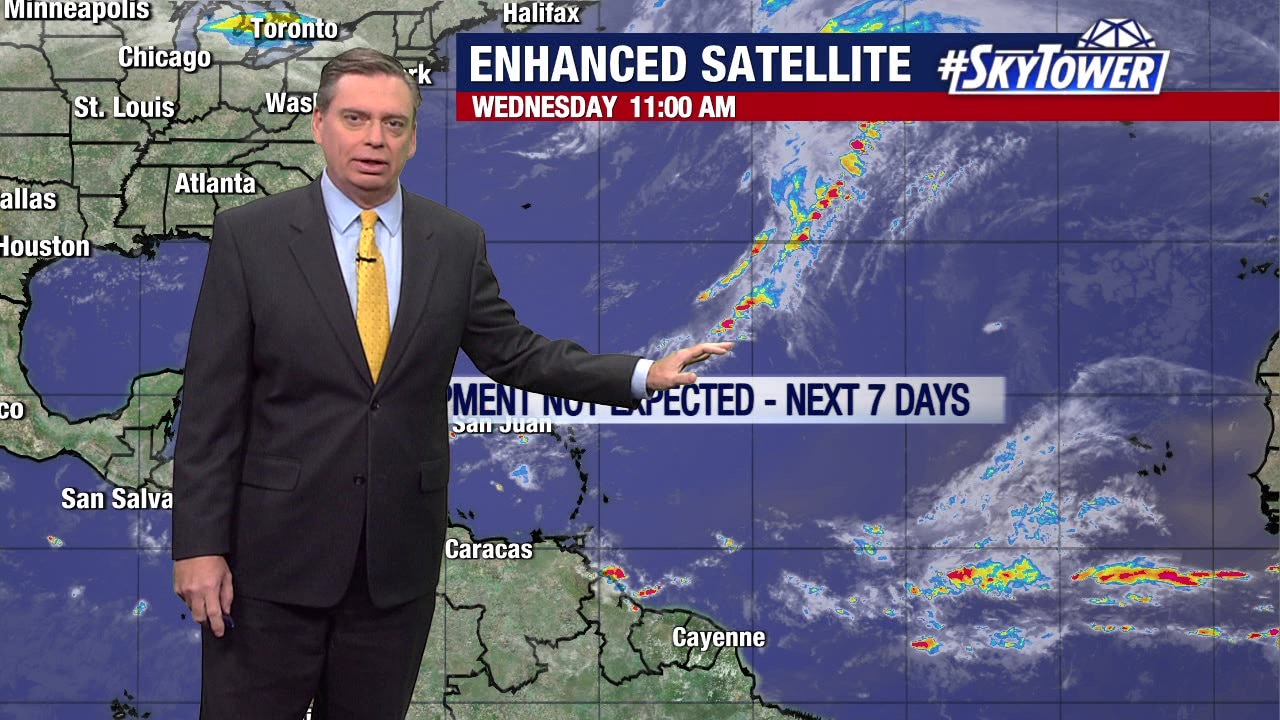
Meteorologist Jim Weber said the tropics remain quiet, with no active fronts on the southeast. A cold front coming in a couple of days could bring something, but for now there is no activity in the tropics.
Meteorologist Jim Weber said the tropics remain quiet, with no active fronts on the southeast. A cold front coming in a couple of days could bring something, but for now there is no activity in the tropics.
Tropics to stay quiet for next week
FOX 13 Meteorologist Jim Weber says all is quiet in the tropics. He does not expect anything to develop over the next week. He says there is strong wind sheer keeping storms at bay. There are 22 days left in the 2023 hurricane season.
FOX 13 Meteorologist Jim Weber says all is quiet in the tropics. He does not expect anything to develop over the next week. He says there is strong wind sheer keeping storms at bay. There are 22 days left in the 2023 hurricane season.

Tropics remain quiet as hurricane season winds down
FOX 13 Meteorologist Jim Weber is counting down to the end of hurricane season. He says it is very quiet at the moment, but there are 23 days left in the season. According to Weber, there are only two names left on the 2023 hurricane list and they may end up not being used. He says he does not expect any tropical development over the next seven days.
FOX 13 Meteorologist Jim Weber is counting down to the end of hurricane season. He says it is very quiet at the moment, but there are 23 days left in the season. According to Weber, there are only two names left on the 2023 hurricane list and they may end up not being used. He says he does not expect any tropical development over the next seven days.

Tropics to remain quiet for next week
FOX 13 Meteorologist Jim Weber says things are quiet in the tropics with only 24 days left in the 2023 hurricane season. He says he does not expect to see anything develop over the next week. He says he is on the lookout for frontal boundaries that work their way southeast and hang out because that increases the potential for tropical development this time of year, but he isn?t seeing that at the moment.
FOX 13 Meteorologist Jim Weber says things are quiet in the tropics with only 24 days left in the 2023 hurricane season. He says he does not expect to see anything develop over the next week. He says he is on the lookout for frontal boundaries that work their way southeast and hang out because that increases the potential for tropical development this time of year, but he isn?t seeing that at the moment.

Tropics quiet over next week
FOX 13 Meteorologist says there is no development expected across the tropical Atlantic over the next seven days. Hurricane season is officially over at the end of this month.
FOX 13 Meteorologist says there is no development expected across the tropical Atlantic over the next seven days. Hurricane season is officially over at the end of this month.

Chance of development in Caribbean Sea
FOX 13 Meteorologist Tony Sadiku says we?re past the peak of hurricane season. According to Sadiku, there?s a 20% chance of development over the next several days for storms in the Caribbean Sea.
FOX 13 Meteorologist Tony Sadiku says we?re past the peak of hurricane season. According to Sadiku, there?s a 20% chance of development over the next several days for storms in the Caribbean Sea.

Tropical system to bring rain to Central America
With less than four weeks to go in the 2023 hurricane season, there is one area of interest that FOX 13 Meteorologist Jim Weber is keeping an eye on. A disorganized system that was once Invest 97 will bring rain to Central America before it makes its way into the Pacific Ocean. Weber says he does not believe the will strengthen.
With less than four weeks to go in the 2023 hurricane season, there is one area of interest that FOX 13 Meteorologist Jim Weber is keeping an eye on. A disorganized system that was once Invest 97 will bring rain to Central America before it makes its way into the Pacific Ocean. Weber says he does not believe the will strengthen.

Tropical wave to head into Pacific
FOX 13 Meteorologist Jim Weber is watching the tropics in the final month of hurricane season. Weber says there is a disorganized tropical wave that was designated as Invest 97, doesn?t look like it has much chance of developing. He says it will drift toward the west, over Central America and out into the Pacific Ocean.
FOX 13 Meteorologist Jim Weber is watching the tropics in the final month of hurricane season. Weber says there is a disorganized tropical wave that was designated as Invest 97, doesn?t look like it has much chance of developing. He says it will drift toward the west, over Central America and out into the Pacific Ocean.

Invest 97 heads toward Central America
FOX 13 Meteorologist Jim Weber is keeping an eye on the tropics as we head into the last month of the 2023 hurricane season. Weber is watching Invest 97 in the Caribbean, which has a 50 percent chance of developing over the next week. He says it?s still disorganized, but it will work its way west toward Central America and eventually into the Pacific Ocean.
FOX 13 Meteorologist Jim Weber is keeping an eye on the tropics as we head into the last month of the 2023 hurricane season. Weber is watching Invest 97 in the Caribbean, which has a 50 percent chance of developing over the next week. He says it?s still disorganized, but it will work its way west toward Central America and eventually into the Pacific Ocean.

Tropical depression may form in Caribbean
FOX 13 Meteorologist Tony Sadiku is keeping an eye on the tropics as October comes to a close. He says there is a disturbance in the eastern Caribbean that has a 70 percent chance of developing into a tropical depression by the end of the week. Sadiku says the system is not expected to impact Florida as the models show it moving due west. He says if it does get a name, it will be called Vince.
FOX 13 Meteorologist Tony Sadiku is keeping an eye on the tropics as October comes to a close. He says there is a disturbance in the eastern Caribbean that has a 70 percent chance of developing into a tropical depression by the end of the week. Sadiku says the system is not expected to impact Florida as the models show it moving due west. He says if it does get a name, it will be called Vince.

System off Florida?s coast not likely to develop
FOX 13 Meteorologist Jim Weber is watching two areas of interest in the tropics as we round out the month of October. An area off the coast of Florida has a 20 percent chance of developing over the next week. He expects it to drift north and then to the east over open waters. In the Caribbean, a system has a 50 percent chance of development due to low wind shear and warm waters.
FOX 13 Meteorologist Jim Weber is watching two areas of interest in the tropics as we round out the month of October. An area off the coast of Florida has a 20 percent chance of developing over the next week. He expects it to drift north and then to the east over open waters. In the Caribbean, a system has a 50 percent chance of development due to low wind shear and warm waters.

Tropical storm may form, Tammy loses strength
FOX 13 Meteorologist Tony Sadiku says that Tammy is winding down as it moves through hostile conditions. According to Sadiku, a depression or tropical storm could develop over the next few days but is not expected to impact Florida.
FOX 13 Meteorologist Tony Sadiku says that Tammy is winding down as it moves through hostile conditions. According to Sadiku, a depression or tropical storm could develop over the next few days but is not expected to impact Florida.

Tropical Storm Tammy may lose strength in few days
FOX 13 Meteorologist Tony Sadiku says that Tropical Storm Tammy?s movement is not impressive over the next couple of days. There is potential for some development in an area in the Caribbean but the chances have gone down, according to Sadiku. There is a 20 percent chance of development over the next week.
FOX 13 Meteorologist Tony Sadiku says that Tropical Storm Tammy?s movement is not impressive over the next couple of days. There is potential for some development in an area in the Caribbean but the chances have gone down, according to Sadiku. There is a 20 percent chance of development over the next week.

Tropical Storm Tammy redevelops in Atlantic
FOX 13 Meteorologist is keeping an eye on the tropics as Tropical Storm Tammy continues to spin in the Atlantic. After strengthening to a hurricane and weakening to an extra-tropical system, Tammy regained tropical storm strength. Weber says it is expected to work its way east and then push down toward the south before dissipating. He is also watching an area in the Caribbean, which has a 30 percent chance of development over the next week.
FOX 13 Meteorologist is keeping an eye on the tropics as Tropical Storm Tammy continues to spin in the Atlantic. After strengthening to a hurricane and weakening to an extra-tropical system, Tammy regained tropical storm strength. Weber says it is expected to work its way east and then push down toward the south before dissipating. He is also watching an area in the Caribbean, which has a 30 percent chance of development over the next week.

Tammy downgraded to non-tropical system
FOX 13 Meteorologist Jim Weber is keeping an eye on the tropics with only two names left on the 2023 hurricane season list. He says Tammy has been downgraded to a non-tropical system after it hit wind shear and cooler waters. Computer models are struggling with the system, according to Weber, He says it may re-acquire tropical characteristics if it moves south and over warm waters as one computer model suggests.
FOX 13 Meteorologist Jim Weber is keeping an eye on the tropics with only two names left on the 2023 hurricane season list. He says Tammy has been downgraded to a non-tropical system after it hit wind shear and cooler waters. Computer models are struggling with the system, according to Weber, He says it may re-acquire tropical characteristics if it moves south and over warm waters as one computer model suggests.

Hurricane Otis makes history
FOX 13 Meteorologist Jim Weber is keeping an eye on the tropics in the wake of Hurricane Otis. The hurricane went from a tropical storm to a Category 5 hurricane in a matter of 24 hours. He describes its intensification as explosive. According to Weber it was the strongest landfall on Mexico?s Pacific coastline. Weber is also watching Hurricane Tammy in the Atlantic, which has strengthened. He says the storm will eventually works its way into stronger winds and cooler waters, which will force it to weaken as it skirts the east side of Bermuda.
FOX 13 Meteorologist Jim Weber is keeping an eye on the tropics in the wake of Hurricane Otis. The hurricane went from a tropical storm to a Category 5 hurricane in a matter of 24 hours. He describes its intensification as explosive. According to Weber it was the strongest landfall on Mexico?s Pacific coastline. Weber is also watching Hurricane Tammy in the Atlantic, which has strengthened. He says the storm will eventually works its way into stronger winds and cooler waters, which will force it to weaken as it skirts the east side of Bermuda.

Hurricane Tammy spins in Atlantic
FOX 13 Meteorologist Jim Weber is keeping an eye on Hurricane Tammy in the Atlantic. He was watching Invest 95, which became a short-lived tropical depression on Monday and has since dissipated. Weber says Hurricane Tammy is expected to weaken over the next several days as it encounters wind shear. He adds that models are still not in agreement as to where the storm will go next.
FOX 13 Meteorologist Jim Weber is keeping an eye on Hurricane Tammy in the Atlantic. He was watching Invest 95, which became a short-lived tropical depression on Monday and has since dissipated. Weber says Hurricane Tammy is expected to weaken over the next several days as it encounters wind shear. He adds that models are still not in agreement as to where the storm will go next.

Hurricane Tammy may strike Bermuda as tropical storm
FOX 13 Meteorologist Jim Weber is keeping an eye on Hurricane Tammy and Invest 95. He says Hurricane Tammy, which effected many islands over the weekend is moving north at seven miles an hour. However, Weber says some computer models show the hurricane eventually making a western turn over Bermuda as a tropical storm or an extra-tropical storm. Invest 95 has a 60 percent chance of strengthening. Weber expects it to drift over Central America over the next few days and eventually enter the Pacific Ocean.
FOX 13 Meteorologist Jim Weber is keeping an eye on Hurricane Tammy and Invest 95. He says Hurricane Tammy, which effected many islands over the weekend is moving north at seven miles an hour. However, Weber says some computer models show the hurricane eventually making a western turn over Bermuda as a tropical storm or an extra-tropical storm. Invest 95 has a 60 percent chance of strengthening. Weber expects it to drift over Central America over the next few days and eventually enter the Pacific Ocean.