

Potential Tropical Cyclone One forms in Gulf, to bring heavy rain to South Florida

TAMPA, Fla. - A disturbance heading for the Sunshine State will bring heavy rain to South Florida, and, at the moment, the forecast shows conditions are not favorable for it to rapidly intensify as it travels through the Gulf.
As of Thursday, the disturbance has formed into Potential Tropical Cyclone One, reports the National Hurricane Center. It was originally Invest 91L.
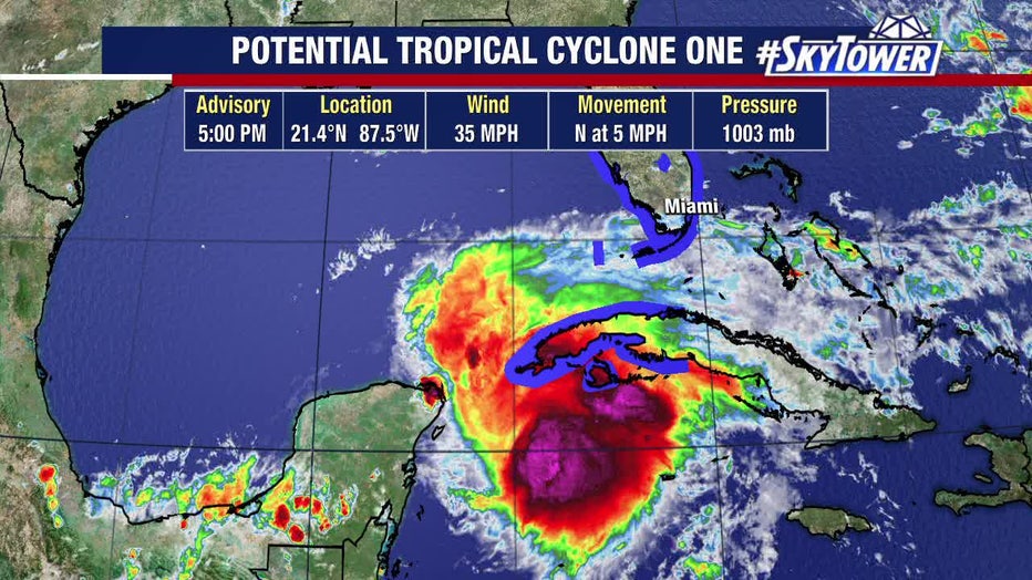
The remnants of former Pacific Hurricane Agatha are in the mix, but the dominant feature appears to be a strong cluster of thunderstorms just east of the Yucatán Peninsula in the Caribbean. The area of disturbed weather has been dubbed, Invest 91L Thursday morning.
FOX 13 meteorologist Dave Osterberg points out that it is attempting to wrap itself around the center, but drier air and upper-level winds are "pretty hostile" and discouraging developing of a low-level circulation.
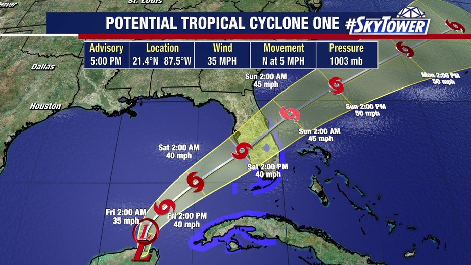
"Could it? Absolutely," he said. "This could easily become a tropical depression, but it shouldn’t be much more than that. It should be a weak system moving into South Florida."
LINK: Track the tropics on MyFOXHurricane.com
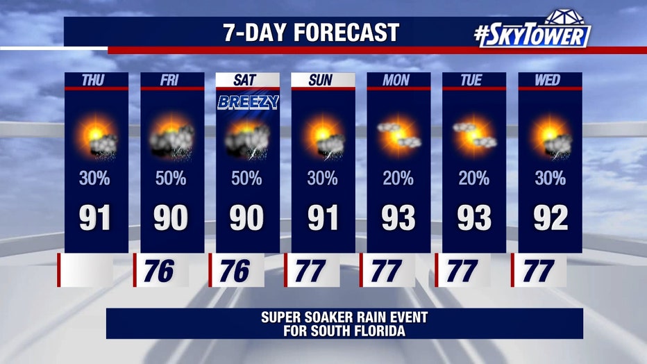
On the current schedule, rain arrives late Thursday, the storm's impacts peak late Friday into Saturday, then the weather significantly improves late Saturday into Sunday.
Because this sharp dip in the upper-level wind flow is pressing on the disturbance from the west, the system is expected to be lopsided, developing into something like a comma shape with its heaviest rain and gustiest winds on the front (or east) side of the storm.
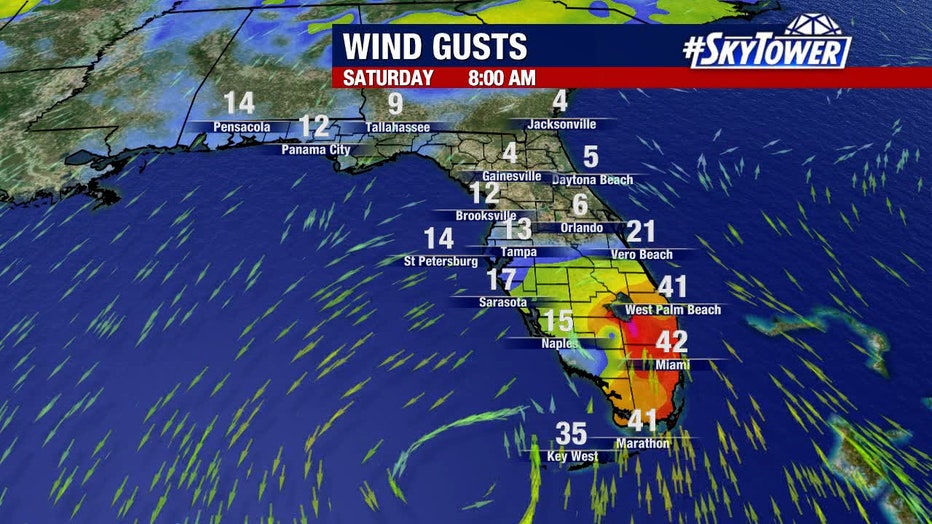
Rainfall totals could be several inches, according to the forecast. The track should be primarily from Fort Myers to Miami, Osterberg explained. Naples could see 7 inches of rain and West Palm could get nearly 8 inches. As for Tampa Bay, the area could get a couple tenths of an inch of rain.
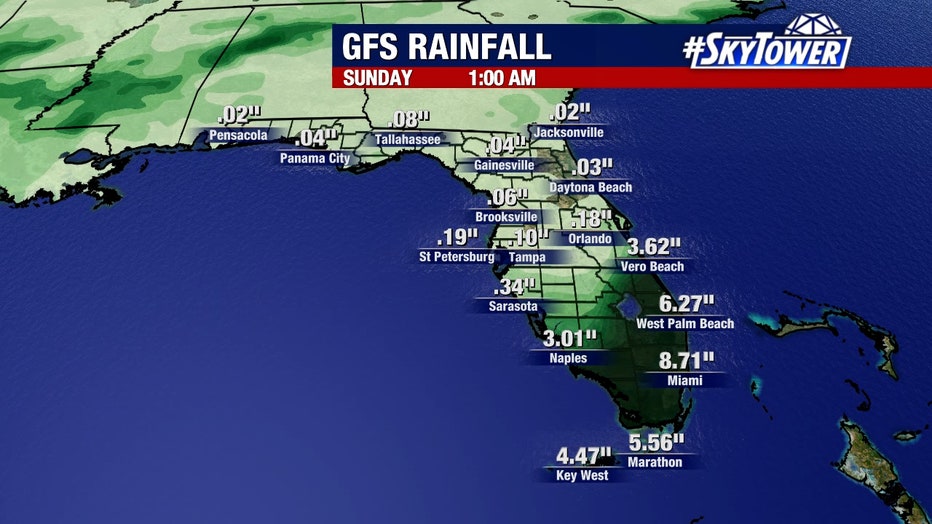
"For instance, let’s just say for the sake of argument this thing was to shove, you know, 40-50 miles to the north, different story," he said. "Now, all of a sudden, Tampa is getting into some heavier rain. We’ll of course watch that but the way it is setting up and the way it looks, the real heavy rain stays down here from Naples to West Palm to Fort Lauderdale to Miami. If that happens to be where you’re heading tomorrow, that’s not going to be fun. We got to look out for flooding in South Florida."
If the disturbance remains south of the region, the Bay Area could experience some scattered showers and some wind.
FOX Weather contributed to this report