

Forecast: TS Nicholas will be 'rainmaker' for Texas, Louisiana

Today’s tropical weather forecast
Meteorologist Jim Weber offers the latest on Tropical Storm Nicholas and other tropical disturbances.
TAMPA, Fla. - Tropical Storm Nicholas was moving up the Gulf Coast on Monday, threatening to bring heavy rain and floods to coastal areas of Texas, Mexico and storm-battered Louisiana.
According to the National Hurricane Center, Nicholas is on a forecast track to pass near the South Texas coast later Monday, then move onshore along the coast of south or central Texas by Monday evening.
"As this moves toward the north-northwest, it may run out of time before it makes landfall to become a hurricane," explained FOX 13's meteorologist Dave Osterberg, "but it’s going to be really close. Regardless, I think this is a rainmaker."

LINK: Track the tropics with MyFOXHurricane.com
A hurricane watch was issued from Port Aransas to Freeport, Texas. Much of the state’s coastline was under a tropical storm warning as the system was expected to bring heavy rain that could cause flash floods and urban flooding.
"This is one of those big gully washing tropical systems, where you’re going to see extensive flooding in southeast Texas and southwest Louisiana," said Osterberg. "Some of the computer models are painting the fact that you could be looking at 10-15 inches of rain with this system."
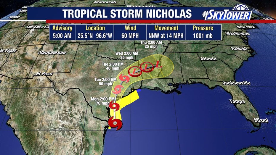
He said as Nicholas works onshore, it is expected to slowly re-curve to the northeast and eventually slide up to the northern Appalachians.
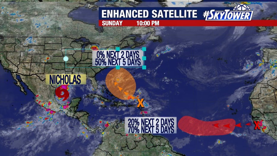
Meanwhile, there are two other areas of interest in the tropics.
"The tropics are very active. Not only do we have a Tropical Storm Nicholas…we got another area with potential of development, east of the Bahamas. Then, we got a big, big tropical wave just getting ready to come off the coast of Africa and this will likely develop over the next couple of days, as well," Osterberg explained. "We’re not done folks. I can tell you, at least, between Nicholas, this other area east of the Bahamas, both of those are not going to cause a threat to [the Bay Area]."
Texas Gov. Greg Abbott said the state has placed rescue teams and resources in the Houston area and along the Texas Gulf Coast.
"This is a storm that could leave heavy rain, as well as wind and probably flooding, in various different regions along the Gulf Coast. We urge you to listen to local weather alerts, heed local warnings," Abbot said in a video message.
Louisiana Gov. John Bel Edwards on Sunday night declared a state of emergency ahead of the storm’s arrival in a state still recovering from Hurricane Ida and last year’s Hurricane Laura and historic flooding.
"The most severe threat to Louisiana is in the southwest portion of the state, where recovery from Hurricane Laura and the May flooding is ongoing. In this area heavy rain and flash flooding are possible. However, it is also likely that all of south Louisiana will see heavy rain this week, including areas recently affected by Hurricane Ida," Edwards said.
The storm was expected to bring the heaviest rainfall west of where Hurricane Ida slammed into Louisiana two weeks ago. Although forecasters did not expect Louisiana to suffer from strong winds again, meteorologist Bob Henson at Yale Climate Connections predicted rainfall could still plague places where the hurricane toppled homes, paralyzed electrical and water infrastructure and left at least 26 people dead.
MORE: Hurricane Ida aftermath: Death toll in Louisiana rises to 26
The Associated Press contributed to this report