

Watching the potential for another East Coast winter storm later this week
Another winter storm might be brewing for the East Coast later this week, and it could impact many of the same areas that just saw heavy snow and ice over the Martin Luther King Jr. holiday weekend.
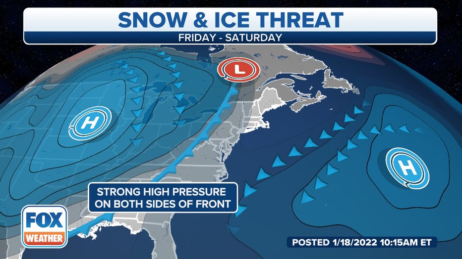
The setup involves an arctic high-pressure system pushing a cold front through the South and East over the next few days, ushering in another blast of frigid temperatures in the wake of the front.
Moisture will be fed into the southern and eastern periphery of the cold air mass, and where temperatures are below freezing, there is an increasing threat of heavy snow and/or ice from the Southeast to the mid-Atlantic states into Friday.
(FOX Weather) ((FOX Weather))
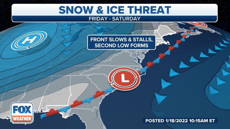
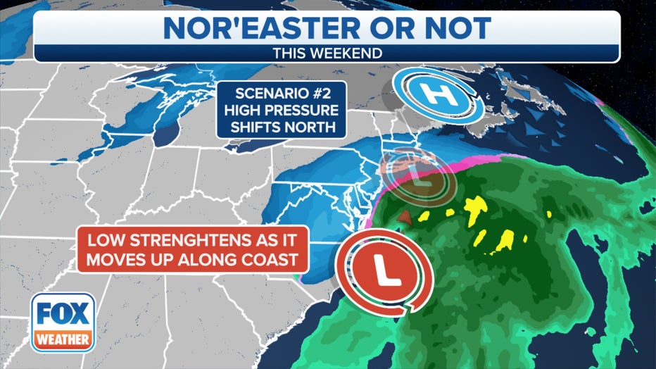
Another piece of the puzzle includes the potential for a coastal low to develop along the cold front, which would enhance the threat of heavy snow for the mid-Atlantic and Northeast on Saturday.
However, uncertainty remains high with respect to this potential coastal storm. Some computer forecast models suggest it could track very close to the coast and have significant impacts along the East Coast, while other models predict the system will track farther offshore by Saturday with minimal impacts in the mid-Atlantic and Northeast.
What we know
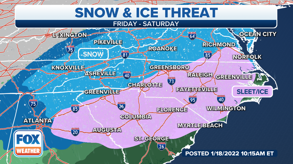
A low-pressure system will likely develop in the Southeast on Friday, then move northward along the East Coast through the weekend.
Precipitation – including snow, sleet, freezing rain and plain rain – will spread northward in association with the area of low pressure.
SNOW, SLEET, FREEZING RAIN AND HAIL: WHAT'S THE DIFFERENCE?
(FOX Weather) ((FOX Weather))
Significant freezing rain is becoming increasingly likely in the Carolinas on Friday and Friday night, which could result in dangerous travel and scattered power outages.
The National Weather Service has already issued Winter Storm Watches for much of the central and eastern Carolinas from Thursday evening through Saturday morning.
What we don't know yet
The timing of the cold front on Thursday remains uncertain, and this will be key in determining how much cold air is available for snow and/or ice in the South.
A faster-moving cold front would bring the cold air in sooner, yielding a greater threat of wintry precipitation, while a slower-moving front would cause the cold air to be delayed, meaning the system could be more wet than wintry.
"Nearly every ensemble solution of the GFS (American model) and the ECMWF (European model) shows some mix of snow, sleet and freezing rain from Georgia to Virginia," said FOX Weather meteorologist and senior weather producer Greg Diamond. "Because of this, we can say with high confidence that these areas should start preparing for yet another round of wintry weather. Exactly who is getting what will be figured out in the coming days."
(FOX Weather)
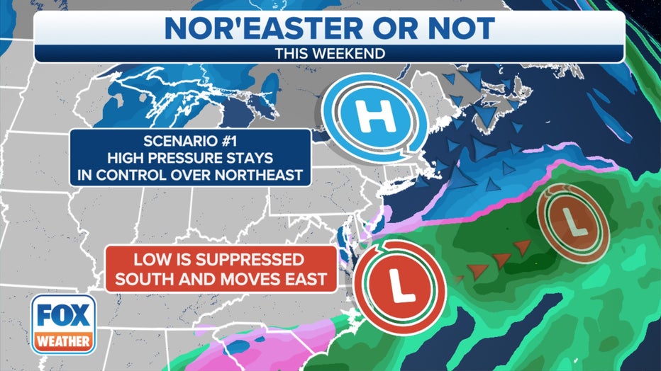
The track of the potential coastal low up the Eastern Seaboard also remains uncertain. Computer forecast models differ in where the coastal storm may develop and track, though recent trends indicate it might move very close to the East Coast.
WEATHER GEEK SPEAK: WHAT'S A EURO OR GFS COMPUTER FORECAST MODEL?
The strength of the coastal storm is another important element that can't yet be determined this far out in time. A stronger low-pressure system would bring more significant impacts, while a weaker one could mean it's more of a nuisance-type system.
(FOX Weather) ((FOX Weather))
"Significant snow in the Northeast remains much more uncertain as the models have to try to correctly forecast multiple areas of spin in the atmosphere, all of which contribute to exactly where this storm will track," Diamond said. "I think, right now, those from New Jersey to coastal Massachusetts have a 50-50 shot of getting plowable snow. Farther inland, the chances are much lower."
Check back with FOX Weather in the days ahead as all these key details come into focus, providing meteorologists with a much clearer picture of any potential impacts from this predicted winter storm later in the week.
(FOX Weather) ((FOX Weather))