

Tampa sets record-breaking heat index of 119 degrees on Tuesday

Tampa weather | Extreme heat Tuesday
FOX 13 Meteorologist Dave Osterberg says part of the Tampa Bay area is under an extreme heat warning on Tuesday, meaning the heat index could top 112 degrees. Conditions will slowly return to normal later this week.
TAMPA, Fla. - Tampa reached another milestone on Tuesday afternoon, reaching an all-time record heat index of 119° at around 2:30 p.m.
The dew point was at 81 and the actual temperature was 97 when we hit that heat index.
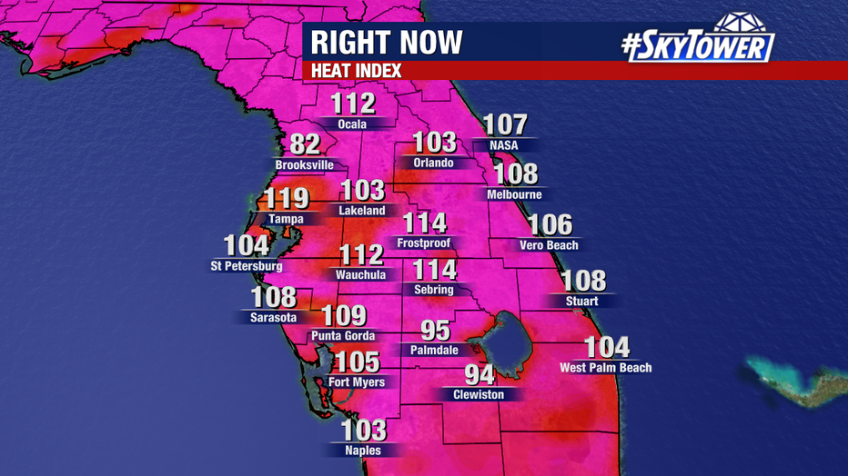
Heat indexes recorded at around 2:30 p.m. on Tuesday.
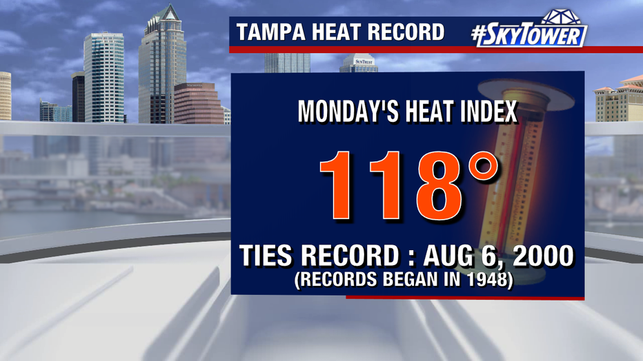
Monday, Tampa International Airport tied the previous all-time record heat index of 118°, which has only happened twice as far as records date back to 1948 – most recently in August 2000 and August 1986.
This comes just a day after Tampa reached 100° for the first time on record on Sunday.
What we know:
Portions of the Tampa Bay area are under an extreme heat warning on Tuesday as temperatures soared above normal, with high humidity driving up the heat index.
The extreme heat warning covers Citrus, Hernando, Hillsborough, Pasco, Pinellas and Polk counties, along with areas north and east of the FOX 13 viewing area.
DeSoto, Hardee, Highlands, Manatee and Sarasota counties are under a heat advisory on Tuesday.
Tuesday was the first time since August 2023 that this much of the Tampa Bay area was under an extreme heat warning, according to Meteorologist Valerie Mills.
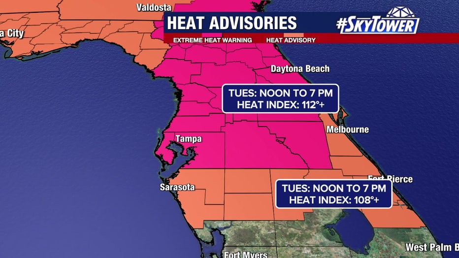
Part of the Tampa Bay area is under an extreme heat warning on Tuesday.
Extreme heat warning vs. heat advisory
By the numbers:
The National Weather Service issues an extreme heat warning "when extremely dangerous heat conditions are expected or occurring."
In this case, the warning has been issued because the heat index could top 112 degrees.
READ: Clearwater Ferry crash: Jeffry Knight charged months after deadly incident
The NWS issues a heat advisory "for dangerous heat conditions that are not expected to reach warning criteria."
"There's not a big difference between these two," FOX 13 Meteorologist Dave Osterberg said. "Both are very dangerous and they're both an alert to you to say ‘hey, let’s slow it down.'"
What to expect the rest of the week
Meteorologist Dave Osterberg says drier air in the mid-levels of the atmosphere will continue to keep rain coverage down in the coming days, with chances in the 30-40% range.
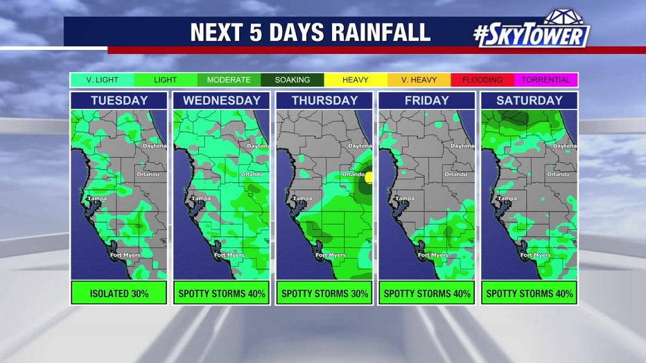
Rain chances will remain relatively low over the next few days before going back up, meteorologists say.
Afternoon temperatures will still hover in the mid-90s, but a return to more normal summer conditions is likely on the way by the latter part of the weekend into next week.
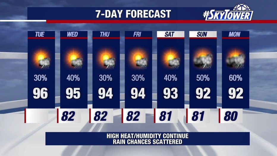
Temperatures will slowly return to normal levels with increasing rain chances by this weekend, meteorologists say.
The Source: This story was written with information from FOX 13 meteorologists and the National Weather Service.