

With minimal damage reported, flood-prone communities watch water levels as Elsa makes landfall

Pinellas asks residents to submit damage reports
Pinellas County officials say they have received minimal reports of damage but will depend on residents to report anything they may have missed as the day goes on.
TAMPA, Fla. - Heavy downpours from then-Hurricane Elsa pummeled Central Florida's southern and interior counties overnight, while coastal communities and low-lying areas were still bracing for possible storm surge this morning. However, as visitors and residents woke up, many said it appeared the Tampa Bay area had dodged a bullet.
Elsa made landfall in Taylor County late this morning as a tropical storm with winds of about 65 mph.
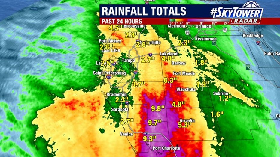
As the storm passed Tampa Bay, Tropical Storm Elsa’s winds began to shift, maintaining the threat for storm surge and flooding – especially after inland sections of Sarasota, Manatee, Highlands, Charlotte, and Desoto counties received nearly 10 inches of rain.
Before Elsa’s arrival Tuesday, Pinellas County limited access to the barrier islands, but those restrictions were lifted by 6:30 a.m. Wednesday. Overnight, only hotel guests, workers along Gulf Boulevard, and residents were allowed access.
County emergency officials have been monitoring the storm all night and received some reports of standing water in Tarpon Springs and Clearwater, but are waiting for reports from residents.
"It’s been better than we hoped," said Dave Connor, a county spokesperson. "So far, most of the damage that we heard of seem to be in the northern part of the county. We are waiting and have our ears are open to the residents of the county to understand where they are seeing damage that we may have not found yet."
Pinellas County residents can submit damage reports here: storm.pinellascounty.org.

Cedar Key braces for Elsa
Last year, Tropical Storm Eta made landfall south of the Cedar Key. As Elsa crawls north along the west coast, the Big Bend braces itself for another landfall.
In Gulfport, like other coastal communities, water was the main concern, but locals were waking up with a sigh of relief. Its waterfront tends to flood, much like it did during Eta just eight months ago. Tuesday night, most of the businesses have tarps and sandbags at their doors. City officials say 7,500 sandbags were handed out over the last four days.
However, besides a few puddles here and there, there was no flooding as residents woke up Wednesday morning. High tide during the overnight hours passed without any flooding, but city officials will still keep an eye on the potential of storm surge during the day.

Tropical Storm Elsa Wednesday midday update
Meteorologist Jim Weber says Elsa is ashore in Florida and will begin heading up the U.S. East Coast.
Over in Hillsborough County, Tampa's Bayshore Boulevard was closed this afternoon between S. Rome and W. Swann due to anticipated high tide and high winds.
Further out in the county, there were some downed trees, including one that landed on top of a vehicle as a driver ventured out around 4:30 a.m. It took place at Bell Shoals Road and Brooker Road in Brandon. Deputies said the driver was not injured.
Sheriff Chad Chronister reported minimal impacts and now the concern turns to storm surge.
"You know what, no one was injured. The calls for service was moderate," he told FOX 13. "I’m a very happy man this morning. I think this showed us all that we are prepared," Sheriff Chronister said. "We take these rehearsals very seriously."

Hillsborough sheriff: Attention turns to flooding
Hillsborough County sheriff said he is happy to learn there has been minimal impacts locally, but is concerned there could be flooding in water-saturated communities.
Thousands woke up without power in the county, and most of it was caused by wind damage, according to the sheriff. He said there are still hazardous conditions and advised against driving if you don’t have to be out on the roadways.
"Those areas…Town ‘N’ Country up into Odessa where it’s already so saturated, I’m worried about flooding there," Sheriff Chronister shared. "That heads the warning, standing water. Don’t drive through it. It’s hard to gauge how deep it is."
While there were no reports of flooding, there are still outer bands moving through on Wednesday morning.
"That storm surge is starting to begin along with that high tide that’s coming, that’s what I’m worried about," he said.
Meanwhile, along Anclote River in Pasco County, the area saw some rain bands overnight, but the water level hasn’t risen and there have been no reports of significant flooding as of Wednesday morning.
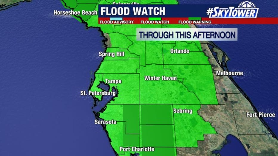
As the day goes on, officials will keep an eye on flood-prone areas as it takes a while for rivers to swell up following a downpour.
Further south, city officials in harder-hit North Port were surveying flooded roadways. A large swath of south-central Florida received over 9 inches of rain, based on radar estimates. With the ground already saturated from this summer's rains, much of that fresh rainfall was still sitting in streets and yards.
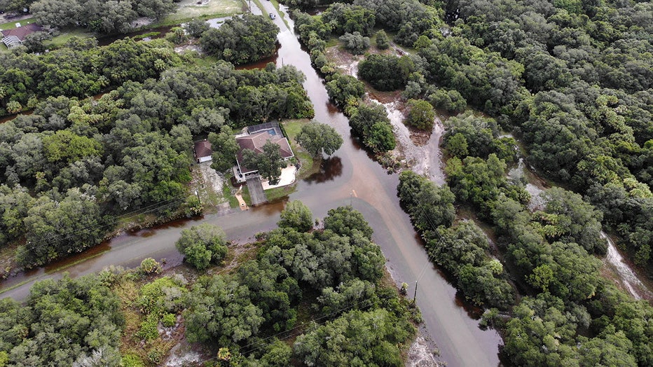
Flooding in the North Port area (courtesy City of North Port)